You are here: Home > Network List > TA - USArray Transportable Network (new EarthScope stations) Stations List
> Station L04D Klamath Falls, OR, USA > Earthquake Result Viewer
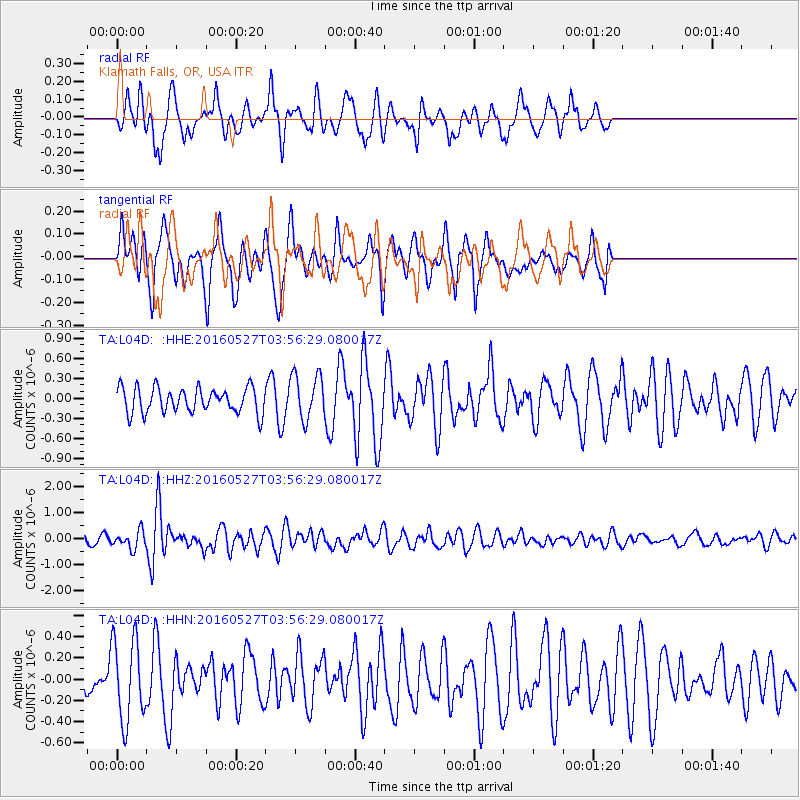
L04D Klamath Falls, OR, USA - Earthquake Result Viewer
*The percent match for this event was below the threshold and hence no stack was calculated.
| Earthquake location: |
Southeast Of Ryukyu Islands |
| Earthquake latitude/longitude: |
27.0/130.2 |
| Earthquake time(UTC): |
2016/05/27 (148) 03:44:29 GMT |
| Earthquake Depth: |
10 km |
| Earthquake Magnitude: |
5.8 MO |
| Earthquake Catalog/Contributor: |
NEIC PDE/NEIC ALERT |
|
| Network: |
TA USArray Transportable Network (new EarthScope stations) |
| Station: |
L04D Klamath Falls, OR, USA |
| Lat/Lon: |
42.22 N/122.30 W |
| Elevation: |
1437 m |
|
| Distance: |
84.1 deg |
| Az: |
45.417 deg |
| Baz: |
301.177 deg |
| Ray Param: |
$rayparam |
*The percent match for this event was below the threshold and hence was not used in the summary stack. |
|
| Radial Match: |
47.381268 % |
| Radial Bump: |
339 |
| Transverse Match: |
56.432957 % |
| Transverse Bump: |
400 |
| SOD ConfigId: |
7422571 |
| Insert Time: |
2019-04-22 15:55:28.796 +0000 |
| GWidth: |
2.5 |
| Max Bumps: |
400 |
| Tol: |
0.001 |
|
Signal To Noise
| Channel | StoN | STA | LTA |
| TA:L04D: :HHZ:20160527T03:56:29.080017Z | 1.9823556 | 3.3190872E-7 | 1.6743148E-7 |
| TA:L04D: :HHN:20160527T03:56:29.080017Z | 2.3229501 | 3.8568433E-7 | 1.6603211E-7 |
| TA:L04D: :HHE:20160527T03:56:29.080017Z | 1.7899332 | 3.3378532E-7 | 1.8647921E-7 |
| Arrivals |
| Ps | |
| PpPs | |
| PsPs/PpSs | |


