You are here: Home > Network List > TA - USArray Transportable Network (new EarthScope stations) Stations List
> Station L20K Farewell, AK, USA > Earthquake Result Viewer
L20K Farewell, AK, USA - Earthquake Result Viewer
| Earthquake location: |
Southeast Of Ryukyu Islands |
| Earthquake latitude/longitude: |
27.0/130.2 |
| Earthquake time(UTC): |
2016/05/27 (148) 03:44:29 GMT |
| Earthquake Depth: |
10 km |
| Earthquake Magnitude: |
5.8 MO |
| Earthquake Catalog/Contributor: |
NEIC PDE/NEIC ALERT |
|
| Network: |
TA USArray Transportable Network (new EarthScope stations) |
| Station: |
L20K Farewell, AK, USA |
| Lat/Lon: |
62.48 N/153.88 W |
| Elevation: |
673 m |
|
| Distance: |
60.0 deg |
| Az: |
31.363 deg |
| Baz: |
271.158 deg |
| Ray Param: |
0.061842605 |
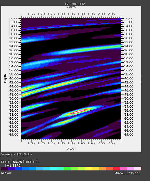
| Estimated Moho Depth: |
56.25 km |
| Estimated Crust Vp/Vs: |
1.89 |
| Assumed Crust Vp: |
6.566 km/s |
| Estimated Crust Vs: |
3.479 km/s |
| Estimated Crust Poisson's Ratio: |
0.30 |
|
| Radial Match: |
89.12187 % |
| Radial Bump: |
400 |
| Transverse Match: |
67.16583 % |
| Transverse Bump: |
400 |
| SOD ConfigId: |
7422571 |
| Insert Time: |
2019-04-22 15:55:30.479 +0000 |
| GWidth: |
2.5 |
| Max Bumps: |
400 |
| Tol: |
0.001 |
|

Signal To Noise
| Channel | StoN | STA | LTA |
| TA:L20K: :BHZ:20160527T03:54:04.950012Z | 4.1387873 | 2.4383692E-7 | 5.8915067E-8 |
| TA:L20K: :BHN:20160527T03:54:04.950012Z | 0.64152855 | 4.1305988E-8 | 6.4386825E-8 |
| TA:L20K: :BHE:20160527T03:54:04.950012Z | 3.3189852 | 1.8544215E-7 | 5.5873144E-8 |
| Arrivals |
| Ps | 8.0 SECOND |
| PpPs | 24 SECOND |
| PsPs/PpSs | 32 SECOND |


