You are here: Home > Network List > TJ - Tajikistan National Seismic Network Stations List
> Station SHAA Shaartuz, Tajikistan > Earthquake Result Viewer
SHAA Shaartuz, Tajikistan - Earthquake Result Viewer

| Earthquake location: |
Southeast Of Ryukyu Islands |
| Earthquake latitude/longitude: |
27.0/130.2 |
| Earthquake time(UTC): |
2016/05/27 (148) 03:44:29 GMT |
| Earthquake Depth: |
10 km |
| Earthquake Magnitude: |
5.8 MO |
| Earthquake Catalog/Contributor: |
NEIC PDE/NEIC ALERT |
|
| Network: |
TJ Tajikistan National Seismic Network |
| Station: |
SHAA Shaartuz, Tajikistan |
| Lat/Lon: |
37.56 N/68.12 E |
| Elevation: |
868 m |
|
| Distance: |
52.7 deg |
| Az: |
298.024 deg |
| Baz: |
82.415 deg |
| Ray Param: |
0.06659778 |
| Estimated Moho Depth: |
60.75 km |
| Estimated Crust Vp/Vs: |
1.60 |
| Assumed Crust Vp: |
6.213 km/s |
| Estimated Crust Vs: |
3.883 km/s |
| Estimated Crust Poisson's Ratio: |
0.18 |
|
| Radial Match: |
93.589836 % |
| Radial Bump: |
400 |
| Transverse Match: |
89.37315 % |
| Transverse Bump: |
400 |
| SOD ConfigId: |
7422571 |
| Insert Time: |
2019-04-22 15:56:07.889 +0000 |
| GWidth: |
2.5 |
| Max Bumps: |
400 |
| Tol: |
0.001 |
|
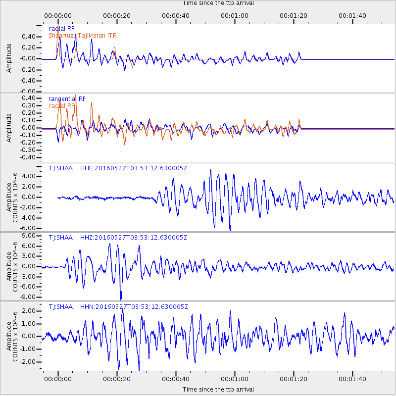
Signal To Noise
| Channel | StoN | STA | LTA |
| TJ:SHAA: :HHZ:20160527T03:53:12.630005Z | 8.679011 | 1.2406631E-6 | 1.4294982E-7 |
| TJ:SHAA: :HHN:20160527T03:53:12.630005Z | 1.6131132 | 2.2664146E-7 | 1.4049941E-7 |
| TJ:SHAA: :HHE:20160527T03:53:12.630005Z | 3.30713 | 4.703282E-7 | 1.4221642E-7 |
| Arrivals |
| Ps | 6.2 SECOND |
| PpPs | 24 SECOND |
| PsPs/PpSs | 30 SECOND |


