You are here: Home > Network List > UW - Pacific Northwest Regional Seismic Network Stations List
> Station LEBA Lebam, WA, USA > Earthquake Result Viewer
LEBA Lebam, WA, USA - Earthquake Result Viewer
*The percent match for this event was below the threshold and hence no stack was calculated.
| Earthquake location: |
Southeast Of Ryukyu Islands |
| Earthquake latitude/longitude: |
27.0/130.2 |
| Earthquake time(UTC): |
2016/05/27 (148) 03:44:29 GMT |
| Earthquake Depth: |
10 km |
| Earthquake Magnitude: |
5.8 MO |
| Earthquake Catalog/Contributor: |
NEIC PDE/NEIC ALERT |
|
| Network: |
UW Pacific Northwest Regional Seismic Network |
| Station: |
LEBA Lebam, WA, USA |
| Lat/Lon: |
46.55 N/123.56 W |
| Elevation: |
73 m |
|
| Distance: |
81.1 deg |
| Az: |
42.121 deg |
| Baz: |
299.875 deg |
| Ray Param: |
$rayparam |
*The percent match for this event was below the threshold and hence was not used in the summary stack. |
|
| Radial Match: |
65.820816 % |
| Radial Bump: |
400 |
| Transverse Match: |
57.44652 % |
| Transverse Bump: |
400 |
| SOD ConfigId: |
7422571 |
| Insert Time: |
2019-04-22 15:56:36.176 +0000 |
| GWidth: |
2.5 |
| Max Bumps: |
400 |
| Tol: |
0.001 |
|
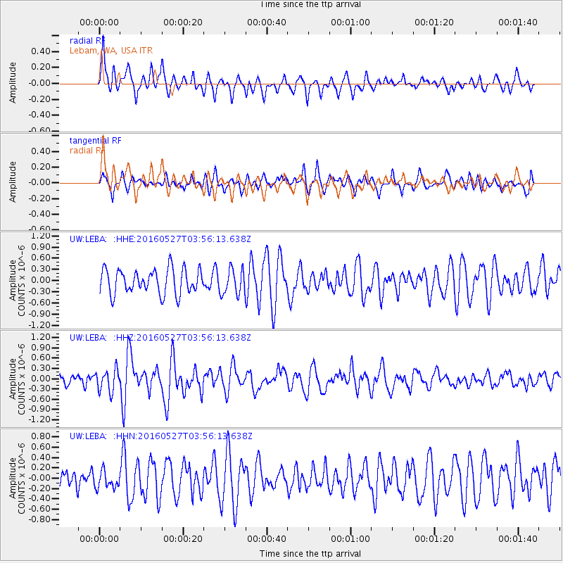
Signal To Noise
| Channel | StoN | STA | LTA |
| UW:LEBA: :HHZ:20160527T03:56:13.638Z | 1.8515967 | 3.214106E-7 | 1.7358563E-7 |
| UW:LEBA: :HHN:20160527T03:56:13.638Z | 0.6751838 | 1.6563253E-7 | 2.4531474E-7 |
| UW:LEBA: :HHE:20160527T03:56:13.638Z | 1.0245391 | 3.4115078E-7 | 3.3297977E-7 |
| Arrivals |
| Ps | |
| PpPs | |
| PsPs/PpSs | |


