You are here: Home > Network List > UW - Pacific Northwest Regional Seismic Network Stations List
> Station PASS Maple Falls, WA, USA > Earthquake Result Viewer
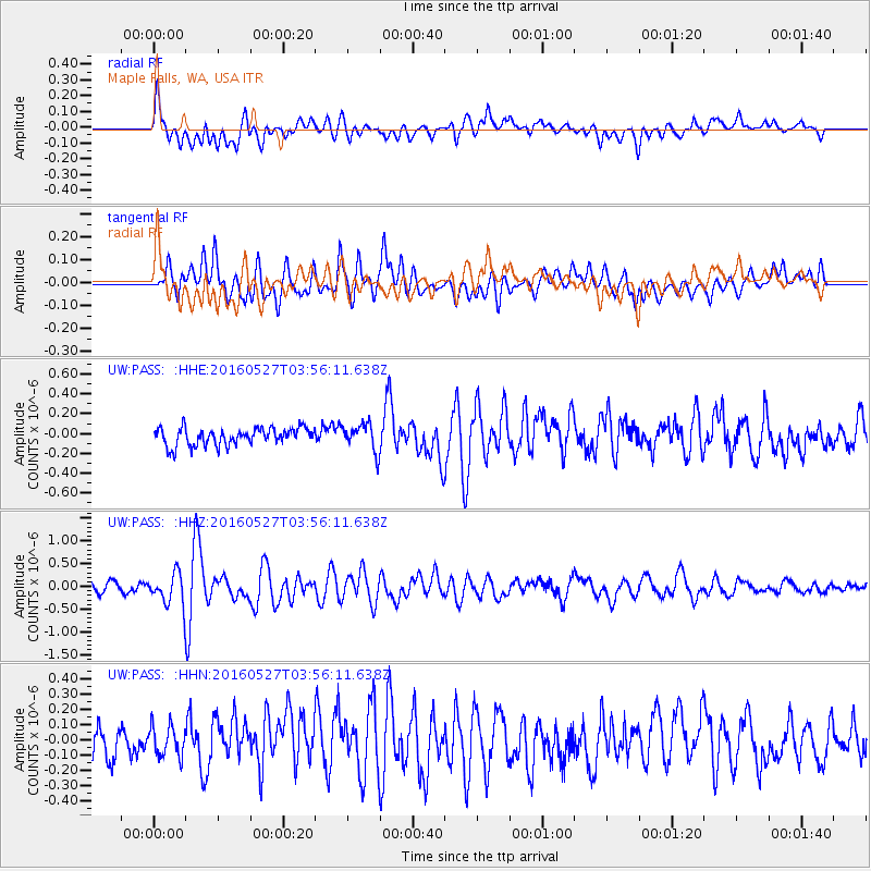
PASS Maple Falls, WA, USA - Earthquake Result Viewer
*The percent match for this event was below the threshold and hence no stack was calculated.
| Earthquake location: |
Southeast Of Ryukyu Islands |
| Earthquake latitude/longitude: |
27.0/130.2 |
| Earthquake time(UTC): |
2016/05/27 (148) 03:44:29 GMT |
| Earthquake Depth: |
10 km |
| Earthquake Magnitude: |
5.8 MO |
| Earthquake Catalog/Contributor: |
NEIC PDE/NEIC ALERT |
|
| Network: |
UW Pacific Northwest Regional Seismic Network |
| Station: |
PASS Maple Falls, WA, USA |
| Lat/Lon: |
49.00 N/122.09 W |
| Elevation: |
174 m |
|
| Distance: |
80.7 deg |
| Az: |
39.466 deg |
| Baz: |
300.547 deg |
| Ray Param: |
$rayparam |
*The percent match for this event was below the threshold and hence was not used in the summary stack. |
|
| Radial Match: |
78.05873 % |
| Radial Bump: |
400 |
| Transverse Match: |
67.34129 % |
| Transverse Bump: |
400 |
| SOD ConfigId: |
7422571 |
| Insert Time: |
2019-04-22 15:56:40.660 +0000 |
| GWidth: |
2.5 |
| Max Bumps: |
400 |
| Tol: |
0.001 |
|
Signal To Noise
| Channel | StoN | STA | LTA |
| UW:PASS: :HHZ:20160527T03:56:11.638Z | 3.5583546 | 3.7981735E-7 | 1.06739606E-7 |
| UW:PASS: :HHN:20160527T03:56:11.638Z | 0.93524086 | 9.861347E-8 | 1.05441785E-7 |
| UW:PASS: :HHE:20160527T03:56:11.638Z | 1.2162868 | 1.0707481E-7 | 8.8034184E-8 |
| Arrivals |
| Ps | |
| PpPs | |
| PsPs/PpSs | |


