You are here: Home > Network List > US - United States National Seismic Network Stations List
> Station BW06 Boulder Array Site 6 (Pinedale), Wyoming, USA > Earthquake Result Viewer
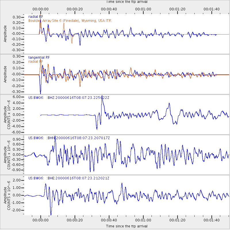
BW06 Boulder Array Site 6 (Pinedale), Wyoming, USA - Earthquake Result Viewer
| Earthquake location: |
Chile-Argentina Border Region |
| Earthquake latitude/longitude: |
-33.9/-70.1 |
| Earthquake time(UTC): |
2000/06/16 (168) 07:55:35 GMT |
| Earthquake Depth: |
120 km |
| Earthquake Magnitude: |
6.2 MB, 6.5 MW, 6.1 MD |
| Earthquake Catalog/Contributor: |
WHDF/NEIC |
|
| Network: |
US United States National Seismic Network |
| Station: |
BW06 Boulder Array Site 6 (Pinedale), Wyoming, USA |
| Lat/Lon: |
42.77 N/109.56 W |
| Elevation: |
2224 m |
|
| Distance: |
84.4 deg |
| Az: |
331.943 deg |
| Baz: |
147.9 deg |
| Ray Param: |
0.045240983 |
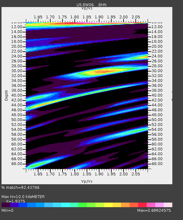
| Estimated Moho Depth: |
10.0 km |
| Estimated Crust Vp/Vs: |
1.94 |
| Assumed Crust Vp: |
6.161 km/s |
| Estimated Crust Vs: |
3.18 km/s |
| Estimated Crust Poisson's Ratio: |
0.32 |
|
| Radial Match: |
92.43786 % |
| Radial Bump: |
400 |
| Transverse Match: |
90.49618 % |
| Transverse Bump: |
400 |
| SOD ConfigId: |
110165 |
| Insert Time: |
2010-03-05 03:33:45.981 +0000 |
| GWidth: |
2.5 |
| Max Bumps: |
400 |
| Tol: |
0.001 |
|
Signal To Noise
| Channel | StoN | STA | LTA |
| US:BW06: :BHN:20000616T08:07:23.207017Z | 6.3418674 | 2.3573733E-7 | 3.7171596E-8 |
| US:BW06: :BHE:20000616T08:07:23.212021Z | 6.5862617 | 5.8718916E-7 | 8.915363E-8 |
| US:BW06: :BHZ:20000616T08:07:23.225022Z | 29.286806 | 1.6725985E-6 | 5.711099E-8 |
| Arrivals |
| Ps | 1.6 SECOND |
| PpPs | 4.7 SECOND |
| PsPs/PpSs | 6.2 SECOND |


