You are here: Home > Network List > US - United States National Seismic Network Stations List
> Station BW06 Boulder Array Site 6 (Pinedale), Wyoming, USA > Earthquake Result Viewer
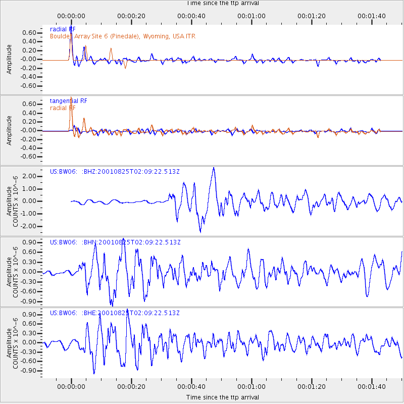
BW06 Boulder Array Site 6 (Pinedale), Wyoming, USA - Earthquake Result Viewer
| Earthquake location: |
South Of Panama |
| Earthquake latitude/longitude: |
7.6/-82.8 |
| Earthquake time(UTC): |
2001/08/25 (237) 02:02:02 GMT |
| Earthquake Depth: |
24 km |
| Earthquake Magnitude: |
5.9 MB, 5.7 MS, 6.2 MW, 6.1 MW |
| Earthquake Catalog/Contributor: |
WHDF/NEIC |
|
| Network: |
US United States National Seismic Network |
| Station: |
BW06 Boulder Array Site 6 (Pinedale), Wyoming, USA |
| Lat/Lon: |
42.77 N/109.56 W |
| Elevation: |
2224 m |
|
| Distance: |
42.2 deg |
| Az: |
330.383 deg |
| Baz: |
138.299 deg |
| Ray Param: |
0.07327738 |
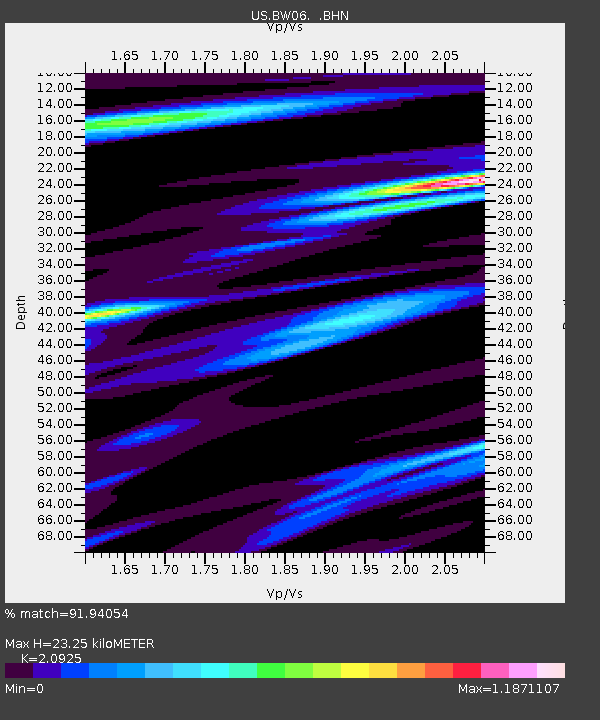
| Estimated Moho Depth: |
23.25 km |
| Estimated Crust Vp/Vs: |
2.09 |
| Assumed Crust Vp: |
6.161 km/s |
| Estimated Crust Vs: |
2.944 km/s |
| Estimated Crust Poisson's Ratio: |
0.35 |
|
| Radial Match: |
91.94054 % |
| Radial Bump: |
400 |
| Transverse Match: |
72.702835 % |
| Transverse Bump: |
400 |
| SOD ConfigId: |
110165 |
| Insert Time: |
2010-03-05 03:34:01.333 +0000 |
| GWidth: |
2.5 |
| Max Bumps: |
400 |
| Tol: |
0.001 |
|
Signal To Noise
| Channel | StoN | STA | LTA |
| US:BW06: :BHN:20010825T02:09:22.513Z | 1.3647536 | 1.4798911E-7 | 1.084365E-7 |
| US:BW06: :BHE:20010825T02:09:22.513Z | 1.9497854 | 1.3801233E-7 | 7.0783344E-8 |
| US:BW06: :BHZ:20010825T02:09:22.513Z | 2.973362 | 3.0966663E-7 | 1.0414697E-7 |
| Arrivals |
| Ps | 4.3 SECOND |
| PpPs | 11 SECOND |
| PsPs/PpSs | 15 SECOND |


