You are here: Home > Network List > US - United States National Seismic Network Stations List
> Station BW06 Boulder Array Site 6 (Pinedale), Wyoming, USA > Earthquake Result Viewer
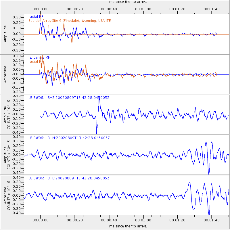
BW06 Boulder Array Site 6 (Pinedale), Wyoming, USA - Earthquake Result Viewer
| Earthquake location: |
Fiji Islands Region |
| Earthquake latitude/longitude: |
-16.3/-176.2 |
| Earthquake time(UTC): |
2002/08/09 (221) 13:31:05 GMT |
| Earthquake Depth: |
364 km |
| Earthquake Magnitude: |
5.5 MB, 6.1 MW, 6.1 MW |
| Earthquake Catalog/Contributor: |
WHDF/NEIC |
|
| Network: |
US United States National Seismic Network |
| Station: |
BW06 Boulder Array Site 6 (Pinedale), Wyoming, USA |
| Lat/Lon: |
42.77 N/109.56 W |
| Elevation: |
2224 m |
|
| Distance: |
84.7 deg |
| Az: |
42.748 deg |
| Baz: |
242.267 deg |
| Ray Param: |
0.044322167 |
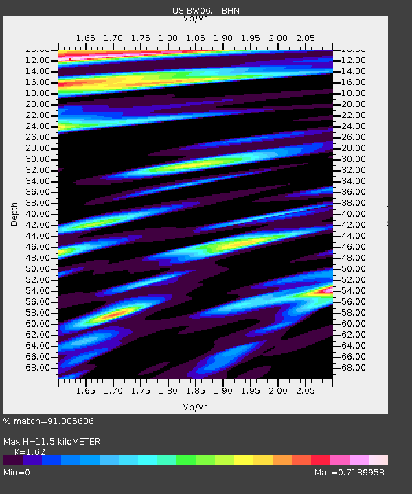
| Estimated Moho Depth: |
11.5 km |
| Estimated Crust Vp/Vs: |
1.62 |
| Assumed Crust Vp: |
6.161 km/s |
| Estimated Crust Vs: |
3.803 km/s |
| Estimated Crust Poisson's Ratio: |
0.19 |
|
| Radial Match: |
91.085686 % |
| Radial Bump: |
400 |
| Transverse Match: |
65.02995 % |
| Transverse Bump: |
400 |
| SOD ConfigId: |
110177 |
| Insert Time: |
2010-03-05 03:34:35.568 +0000 |
| GWidth: |
2.5 |
| Max Bumps: |
400 |
| Tol: |
0.001 |
|
Signal To Noise
| Channel | StoN | STA | LTA |
| US:BW06: :BHN:20020809T13:42:28.045005Z | 2.838042 | 5.837778E-8 | 2.0569738E-8 |
| US:BW06: :BHE:20020809T13:42:28.045005Z | 2.018485 | 5.71377E-8 | 2.8307218E-8 |
| US:BW06: :BHZ:20020809T13:42:28.045005Z | 4.2790275 | 1.8502901E-7 | 4.32409E-8 |
| Arrivals |
| Ps | 1.2 SECOND |
| PpPs | 4.8 SECOND |
| PsPs/PpSs | 6.0 SECOND |


