You are here: Home > Network List > CN - Canadian National Seismograph Network Stations List
> Station INK INUVIK, NT > Earthquake Result Viewer
INK INUVIK, NT - Earthquake Result Viewer
*The percent match for this event was below the threshold and hence no stack was calculated.
| Earthquake location: |
Fiji Islands Region |
| Earthquake latitude/longitude: |
-20.8/-178.7 |
| Earthquake time(UTC): |
2016/05/27 (148) 04:08:44 GMT |
| Earthquake Depth: |
572 km |
| Earthquake Magnitude: |
6.4 MO |
| Earthquake Catalog/Contributor: |
NEIC PDE/NEIC ALERT |
|
| Network: |
CN Canadian National Seismograph Network |
| Station: |
INK INUVIK, NT |
| Lat/Lon: |
68.31 N/133.53 W |
| Elevation: |
44 m |
|
| Distance: |
94.8 deg |
| Az: |
15.336 deg |
| Baz: |
221.715 deg |
| Ray Param: |
$rayparam |
*The percent match for this event was below the threshold and hence was not used in the summary stack. |
|
| Radial Match: |
66.70582 % |
| Radial Bump: |
400 |
| Transverse Match: |
68.23991 % |
| Transverse Bump: |
400 |
| SOD ConfigId: |
7422571 |
| Insert Time: |
2019-04-22 16:11:31.075 +0000 |
| GWidth: |
2.5 |
| Max Bumps: |
400 |
| Tol: |
0.001 |
|
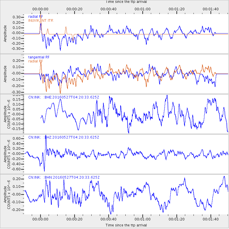
Signal To Noise
| Channel | StoN | STA | LTA |
| CN:INK: :BHZ:20160527T04:20:33.625Z | 3.8993306 | 3.5480502E-7 | 9.0991264E-8 |
| CN:INK: :BHN:20160527T04:20:33.625Z | 1.8510048 | 7.8722515E-8 | 4.2529607E-8 |
| CN:INK: :BHE:20160527T04:20:33.625Z | 0.99148494 | 7.151868E-8 | 7.213289E-8 |
| Arrivals |
| Ps | |
| PpPs | |
| PsPs/PpSs | |


