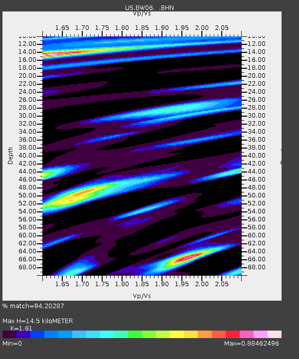
BW06 Boulder Array Site 6 (Pinedale), Wyoming, USA - Earthquake Result Viewer
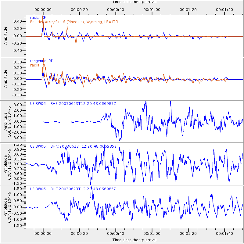
Earthquake location: Rat Islands, Aleutian Islands
Earthquake latitude/longitude: 51.4/176.8
Earthquake time(UTC): 2003/06/23 (174) 12:12:34 GMT
Earthquake Depth: 20 km
Earthquake Magnitude: 6.3 MB, 7.0 MS, 6.9 MW, 6.8 MW
Earthquake Catalog/Contributor: WHDF/NEIC
Network: US United States National Seismic Network
Station: BW06 Boulder Array Site 6 (Pinedale), Wyoming, USA
Lat/Lon: 42.77 N/109.56 W
Elevation: 2224 m
Distance: 48.9 deg
Az: 69.666 deg
Baz: 307.156 deg
Ray Param: 0.06902426
Estimated Moho Depth: 14.5 km
Estimated Crust Vp/Vs: 1.61
Assumed Crust Vp: 6.161 km/s
Estimated Crust Vs: 3.827 km/s
Estimated Crust Poisson's Ratio: 0.19
Radial Match: 94.20287 %
Radial Bump: 400
Transverse Match: 88.81563 %
Transverse Bump: 400
SOD ConfigId: 110177
Insert Time: 2010-03-05 03:35:29.379 +0000
GWidth: 2.5
Max Bumps: 400
Tol: 0.001

Signal To Noise

ChannelStoNSTALTA
US:BW06: :BHN:20030623T12:20:48.066985Z4.5222921.7722606E-73.9189427E-8
US:BW06: :BHE:20030623T12:20:48.066985Z8.60893251.9849863E-72.3057286E-8
US:BW06: :BHZ:20030623T12:20:48.066985Z12.2094536.5165744E-75.3373192E-8
Arrivals
Ps1.5 SECOND
PpPs5.8 SECOND
PsPs/PpSs7.3 SECOND