You are here: Home > Network List > US - United States National Seismic Network Stations List
> Station BW06 Boulder Array Site 6 (Pinedale), Wyoming, USA > Earthquake Result Viewer
BW06 Boulder Array Site 6 (Pinedale), Wyoming, USA - Earthquake Result Viewer
| Earthquake location: |
Fiji Islands Region |
| Earthquake latitude/longitude: |
-21.1/-176.6 |
| Earthquake time(UTC): |
2003/07/27 (208) 02:04:11 GMT |
| Earthquake Depth: |
213 km |
| Earthquake Magnitude: |
5.9 MB, 6.6 MW, 6.6 MW |
| Earthquake Catalog/Contributor: |
WHDF/NEIC |
|
| Network: |
US United States National Seismic Network |
| Station: |
BW06 Boulder Array Site 6 (Pinedale), Wyoming, USA |
| Lat/Lon: |
42.77 N/109.56 W |
| Elevation: |
2224 m |
|
| Distance: |
88.5 deg |
| Az: |
42.705 deg |
| Baz: |
239.33 deg |
| Ray Param: |
0.04206058 |
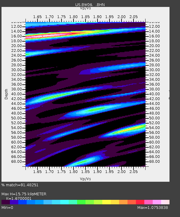
| Estimated Moho Depth: |
15.75 km |
| Estimated Crust Vp/Vs: |
1.67 |
| Assumed Crust Vp: |
6.161 km/s |
| Estimated Crust Vs: |
3.689 km/s |
| Estimated Crust Poisson's Ratio: |
0.22 |
|
| Radial Match: |
91.48251 % |
| Radial Bump: |
400 |
| Transverse Match: |
86.31531 % |
| Transverse Bump: |
400 |
| SOD ConfigId: |
110177 |
| Insert Time: |
2010-03-05 03:35:48.077 +0000 |
| GWidth: |
2.5 |
| Max Bumps: |
400 |
| Tol: |
0.001 |
|
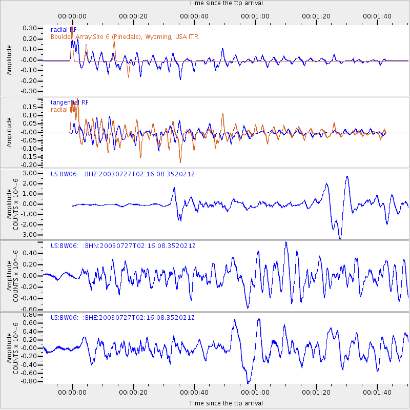
Signal To Noise
| Channel | StoN | STA | LTA |
| US:BW06: :BHN:20030727T02:16:08.352021Z | 1.4693512 | 6.389792E-8 | 4.348717E-8 |
| US:BW06: :BHE:20030727T02:16:08.352021Z | 3.1733556 | 1.4362168E-7 | 4.5258616E-8 |
| US:BW06: :BHZ:20030727T02:16:08.352021Z | 10.863127 | 6.9149985E-7 | 6.365569E-8 |
| Arrivals |
| Ps | 1.7 SECOND |
| PpPs | 6.7 SECOND |
| PsPs/PpSs | 8.4 SECOND |


