You are here: Home > Network List > JP - Japan Meteorological Agency Seismic Network Stations List
> Station JMM Miyagi Marumori > Earthquake Result Viewer
JMM Miyagi Marumori - Earthquake Result Viewer
| Earthquake location: |
Fiji Islands Region |
| Earthquake latitude/longitude: |
-20.8/-178.7 |
| Earthquake time(UTC): |
2016/05/27 (148) 04:08:44 GMT |
| Earthquake Depth: |
572 km |
| Earthquake Magnitude: |
6.4 MO |
| Earthquake Catalog/Contributor: |
NEIC PDE/NEIC ALERT |
|
| Network: |
JP Japan Meteorological Agency Seismic Network |
| Station: |
JMM Miyagi Marumori |
| Lat/Lon: |
37.87 N/140.79 E |
| Elevation: |
100 m |
|
| Distance: |
69.7 deg |
| Az: |
326.745 deg |
| Baz: |
139.595 deg |
| Ray Param: |
0.053478386 |
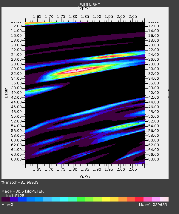
| Estimated Moho Depth: |
30.5 km |
| Estimated Crust Vp/Vs: |
1.81 |
| Assumed Crust Vp: |
6.24 km/s |
| Estimated Crust Vs: |
3.443 km/s |
| Estimated Crust Poisson's Ratio: |
0.28 |
|
| Radial Match: |
81.98933 % |
| Radial Bump: |
400 |
| Transverse Match: |
72.82586 % |
| Transverse Bump: |
400 |
| SOD ConfigId: |
7422571 |
| Insert Time: |
2019-04-22 16:12:37.886 +0000 |
| GWidth: |
2.5 |
| Max Bumps: |
400 |
| Tol: |
0.001 |
|

Signal To Noise
| Channel | StoN | STA | LTA |
| JP:JMM: :BHZ:20160527T04:18:26.450012Z | 7.6891003 | 3.2463684E-6 | 4.2220393E-7 |
| JP:JMM: :BHN:20160527T04:18:26.450012Z | 2.9265616 | 9.773319E-7 | 3.3395227E-7 |
| JP:JMM: :BHE:20160527T04:18:26.450012Z | 4.7374434 | 1.2920443E-6 | 2.727303E-7 |
| Arrivals |
| Ps | 4.1 SECOND |
| PpPs | 13 SECOND |
| PsPs/PpSs | 17 SECOND |


