You are here: Home > Network List > WI - West Indies IPGP Network Stations List
> Station BIM Morne Bigot, Anses d'Arlets, Martinique > Earthquake Result Viewer
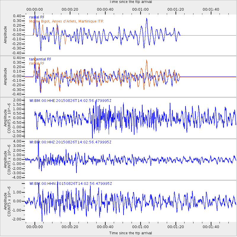
BIM Morne Bigot, Anses d'Arlets, Martinique - Earthquake Result Viewer
*The percent match for this event was below the threshold and hence no stack was calculated.
| Earthquake location: |
South Sandwich Islands Region |
| Earthquake latitude/longitude: |
-57.5/-26.0 |
| Earthquake time(UTC): |
2015/08/26 (238) 13:51:39 GMT |
| Earthquake Depth: |
64 km |
| Earthquake Magnitude: |
5.7 MB |
| Earthquake Catalog/Contributor: |
NEIC PDE/NEIC COMCAT |
|
| Network: |
WI West Indies IPGP Network |
| Station: |
BIM Morne Bigot, Anses d'Arlets, Martinique |
| Lat/Lon: |
14.52 N/61.07 W |
| Elevation: |
391 m |
|
| Distance: |
77.4 deg |
| Az: |
325.196 deg |
| Baz: |
161.441 deg |
| Ray Param: |
$rayparam |
*The percent match for this event was below the threshold and hence was not used in the summary stack. |
|
| Radial Match: |
60.16865 % |
| Radial Bump: |
400 |
| Transverse Match: |
57.1603 % |
| Transverse Bump: |
400 |
| SOD ConfigId: |
1085051 |
| Insert Time: |
2015-09-09 14:07:40.975 +0000 |
| GWidth: |
2.5 |
| Max Bumps: |
400 |
| Tol: |
0.001 |
|
Signal To Noise
| Channel | StoN | STA | LTA |
| WI:BIM:00:HHZ:20150826T14:02:56.479995Z | 5.128075 | 1.1929651E-6 | 2.3263411E-7 |
| WI:BIM:00:HHN:20150826T14:02:56.479995Z | 1.8893291 | 7.856733E-7 | 4.1584778E-7 |
| WI:BIM:00:HHE:20150826T14:02:56.479995Z | 1.8912807 | 8.5036004E-7 | 4.496213E-7 |
| Arrivals |
| Ps | |
| PpPs | |
| PsPs/PpSs | |


