You are here: Home > Network List > US - United States National Seismic Network Stations List
> Station BW06 Boulder Array Site 6 (Pinedale), Wyoming, USA > Earthquake Result Viewer
BW06 Boulder Array Site 6 (Pinedale), Wyoming, USA - Earthquake Result Viewer
| Earthquake location: |
Tonga Islands |
| Earthquake latitude/longitude: |
-16.8/-174.2 |
| Earthquake time(UTC): |
2004/01/25 (025) 11:43:11 GMT |
| Earthquake Depth: |
130 km |
| Earthquake Magnitude: |
6.4 MB, 6.7 MW, 6.7 MW |
| Earthquake Catalog/Contributor: |
WHDF/NEIC |
|
| Network: |
US United States National Seismic Network |
| Station: |
BW06 Boulder Array Site 6 (Pinedale), Wyoming, USA |
| Lat/Lon: |
42.77 N/109.56 W |
| Elevation: |
2224 m |
|
| Distance: |
83.8 deg |
| Az: |
42.012 deg |
| Baz: |
240.509 deg |
| Ray Param: |
0.045618095 |
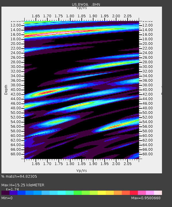
| Estimated Moho Depth: |
15.25 km |
| Estimated Crust Vp/Vs: |
1.74 |
| Assumed Crust Vp: |
6.161 km/s |
| Estimated Crust Vs: |
3.541 km/s |
| Estimated Crust Poisson's Ratio: |
0.25 |
|
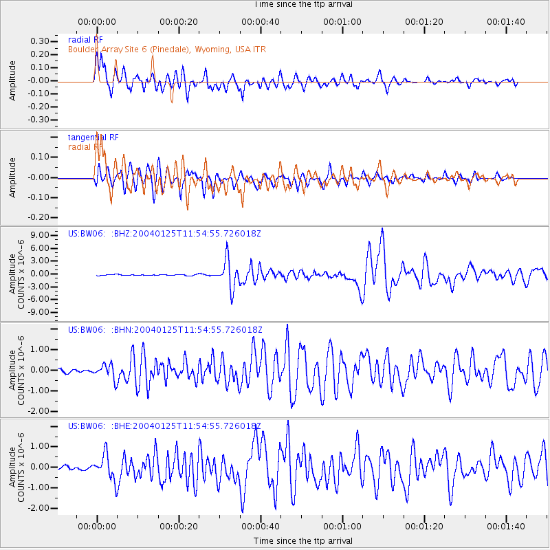
| Radial Match: |
94.82305 % |
| Radial Bump: |
400 |
| Transverse Match: |
85.08362 % |
| Transverse Bump: |
400 |
| SOD ConfigId: |
110177 |
| Insert Time: |
2010-03-05 03:36:43.243 +0000 |
| GWidth: |
2.5 |
| Max Bumps: |
400 |
| Tol: |
0.001 |
|
Signal To Noise
| Channel | StoN | STA | LTA |
| US:BW06: :BHN:20040125T11:54:55.726018Z | 1.7572547 | 3.659392E-7 | 2.0824483E-7 |
| US:BW06: :BHE:20040125T11:54:55.726018Z | 4.420721 | 6.306258E-7 | 1.4265224E-7 |
| US:BW06: :BHZ:20040125T11:54:55.726018Z | 29.732977 | 3.3890803E-6 | 1.1398389E-7 |
| Arrivals |
| Ps | 1.9 SECOND |
| PpPs | 6.6 SECOND |
| PsPs/PpSs | 8.5 SECOND |


