You are here: Home > Network List > TA - USArray Transportable Network (new EarthScope stations) Stations List
> Station J20K Nowitna River, AK, USA > Earthquake Result Viewer
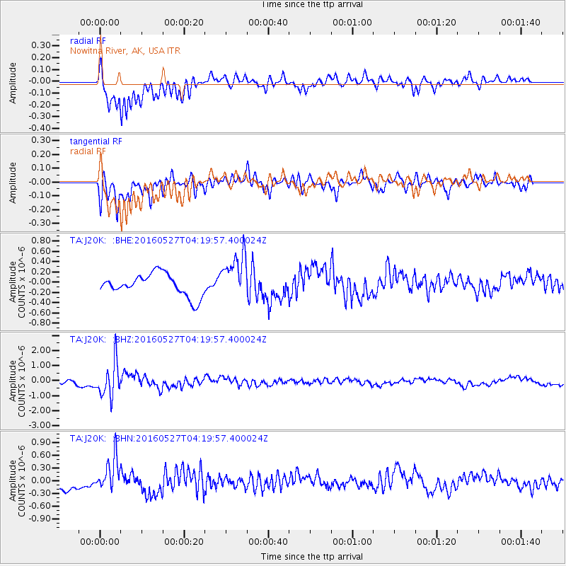
J20K Nowitna River, AK, USA - Earthquake Result Viewer
*The percent match for this event was below the threshold and hence no stack was calculated.
| Earthquake location: |
Fiji Islands Region |
| Earthquake latitude/longitude: |
-20.8/-178.7 |
| Earthquake time(UTC): |
2016/05/27 (148) 04:08:44 GMT |
| Earthquake Depth: |
572 km |
| Earthquake Magnitude: |
6.4 MO |
| Earthquake Catalog/Contributor: |
NEIC PDE/NEIC ALERT |
|
| Network: |
TA USArray Transportable Network (new EarthScope stations) |
| Station: |
J20K Nowitna River, AK, USA |
| Lat/Lon: |
64.18 N/154.15 W |
| Elevation: |
314 m |
|
| Distance: |
86.8 deg |
| Az: |
10.49 deg |
| Baz: |
202.885 deg |
| Ray Param: |
$rayparam |
*The percent match for this event was below the threshold and hence was not used in the summary stack. |
|
| Radial Match: |
83.877205 % |
| Radial Bump: |
400 |
| Transverse Match: |
79.436325 % |
| Transverse Bump: |
400 |
| SOD ConfigId: |
7422571 |
| Insert Time: |
2019-04-22 16:14:57.157 +0000 |
| GWidth: |
2.5 |
| Max Bumps: |
400 |
| Tol: |
0.001 |
|
Signal To Noise
| Channel | StoN | STA | LTA |
| TA:J20K: :BHZ:20160527T04:19:57.400024Z | 6.019663 | 1.1477996E-6 | 1.9067507E-7 |
| TA:J20K: :BHN:20160527T04:19:57.400024Z | 2.2050753 | 4.1281808E-7 | 1.872127E-7 |
| TA:J20K: :BHE:20160527T04:19:57.400024Z | 2.0698068 | 4.4366084E-7 | 2.143489E-7 |
| Arrivals |
| Ps | |
| PpPs | |
| PsPs/PpSs | |


