You are here: Home > Network List > TA - USArray Transportable Network (new EarthScope stations) Stations List
> Station J25K Salcha River, AK, USA > Earthquake Result Viewer
J25K Salcha River, AK, USA - Earthquake Result Viewer
*The percent match for this event was below the threshold and hence no stack was calculated.
| Earthquake location: |
Fiji Islands Region |
| Earthquake latitude/longitude: |
-20.8/-178.7 |
| Earthquake time(UTC): |
2016/05/27 (148) 04:08:44 GMT |
| Earthquake Depth: |
572 km |
| Earthquake Magnitude: |
6.4 MO |
| Earthquake Catalog/Contributor: |
NEIC PDE/NEIC ALERT |
|
| Network: |
TA USArray Transportable Network (new EarthScope stations) |
| Station: |
J25K Salcha River, AK, USA |
| Lat/Lon: |
64.61 N/145.37 W |
| Elevation: |
949 m |
|
| Distance: |
89.0 deg |
| Az: |
13.693 deg |
| Baz: |
210.91 deg |
| Ray Param: |
$rayparam |
*The percent match for this event was below the threshold and hence was not used in the summary stack. |
|
| Radial Match: |
60.623657 % |
| Radial Bump: |
362 |
| Transverse Match: |
60.21171 % |
| Transverse Bump: |
400 |
| SOD ConfigId: |
7422571 |
| Insert Time: |
2019-04-22 16:14:57.406 +0000 |
| GWidth: |
2.5 |
| Max Bumps: |
400 |
| Tol: |
0.001 |
|
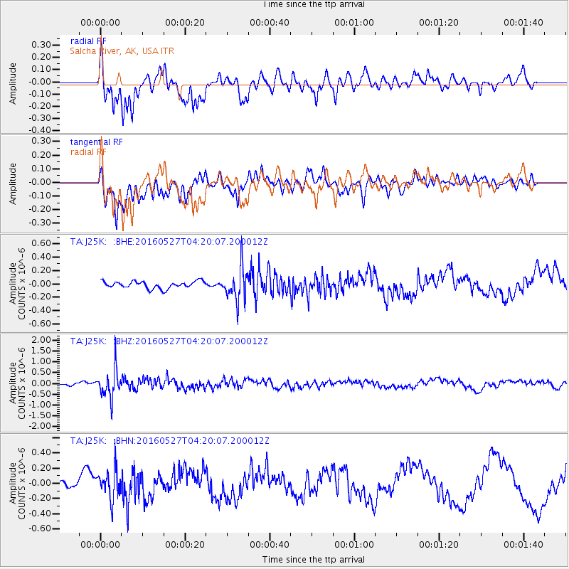
Signal To Noise
| Channel | StoN | STA | LTA |
| TA:J25K: :BHZ:20160527T04:20:07.200012Z | 8.213104 | 6.673334E-7 | 8.1252274E-8 |
| TA:J25K: :BHN:20160527T04:20:07.200012Z | 2.2480597 | 1.9894212E-7 | 8.849503E-8 |
| TA:J25K: :BHE:20160527T04:20:07.200012Z | 4.8478317 | 2.5702823E-7 | 5.3019214E-8 |
| Arrivals |
| Ps | |
| PpPs | |
| PsPs/PpSs | |


