You are here: Home > Network List > TA - USArray Transportable Network (new EarthScope stations) Stations List
> Station L20K Farewell, AK, USA > Earthquake Result Viewer
L20K Farewell, AK, USA - Earthquake Result Viewer

| Earthquake location: |
Fiji Islands Region |
| Earthquake latitude/longitude: |
-20.8/-178.7 |
| Earthquake time(UTC): |
2016/05/27 (148) 04:08:44 GMT |
| Earthquake Depth: |
572 km |
| Earthquake Magnitude: |
6.4 MO |
| Earthquake Catalog/Contributor: |
NEIC PDE/NEIC ALERT |
|
| Network: |
TA USArray Transportable Network (new EarthScope stations) |
| Station: |
L20K Farewell, AK, USA |
| Lat/Lon: |
62.48 N/153.88 W |
| Elevation: |
673 m |
|
| Distance: |
85.3 deg |
| Az: |
11.27 deg |
| Baz: |
203.176 deg |
| Ray Param: |
0.043200377 |
| Estimated Moho Depth: |
67.75 km |
| Estimated Crust Vp/Vs: |
1.84 |
| Assumed Crust Vp: |
6.566 km/s |
| Estimated Crust Vs: |
3.564 km/s |
| Estimated Crust Poisson's Ratio: |
0.29 |
|
| Radial Match: |
84.498726 % |
| Radial Bump: |
400 |
| Transverse Match: |
80.18134 % |
| Transverse Bump: |
400 |
| SOD ConfigId: |
7422571 |
| Insert Time: |
2019-04-22 16:15:08.055 +0000 |
| GWidth: |
2.5 |
| Max Bumps: |
400 |
| Tol: |
0.001 |
|
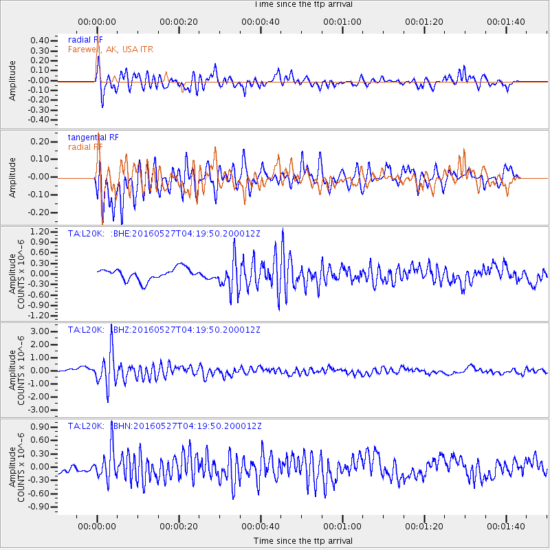
Signal To Noise
| Channel | StoN | STA | LTA |
| TA:L20K: :BHZ:20160527T04:19:50.200012Z | 6.527553 | 1.31948E-6 | 2.0214007E-7 |
| TA:L20K: :BHN:20160527T04:19:50.200012Z | 3.4777849 | 3.6294094E-7 | 1.04359806E-7 |
| TA:L20K: :BHE:20160527T04:19:50.200012Z | 2.5826252 | 4.327619E-7 | 1.6756667E-7 |
| Arrivals |
| Ps | 8.9 SECOND |
| PpPs | 29 SECOND |
| PsPs/PpSs | 38 SECOND |


