You are here: Home > Network List > UW - Pacific Northwest Regional Seismic Network Stations List
> Station LCCR Mulino, OR, USA > Earthquake Result Viewer
LCCR Mulino, OR, USA - Earthquake Result Viewer
*The percent match for this event was below the threshold and hence no stack was calculated.
| Earthquake location: |
Fiji Islands Region |
| Earthquake latitude/longitude: |
-20.8/-178.7 |
| Earthquake time(UTC): |
2016/05/27 (148) 04:08:44 GMT |
| Earthquake Depth: |
572 km |
| Earthquake Magnitude: |
6.4 MO |
| Earthquake Catalog/Contributor: |
NEIC PDE/NEIC ALERT |
|
| Network: |
UW Pacific Northwest Regional Seismic Network |
| Station: |
LCCR Mulino, OR, USA |
| Lat/Lon: |
45.21 N/122.48 W |
| Elevation: |
273 m |
|
| Distance: |
83.2 deg |
| Az: |
36.266 deg |
| Baz: |
231.513 deg |
| Ray Param: |
$rayparam |
*The percent match for this event was below the threshold and hence was not used in the summary stack. |
|
| Radial Match: |
65.077034 % |
| Radial Bump: |
400 |
| Transverse Match: |
64.27631 % |
| Transverse Bump: |
400 |
| SOD ConfigId: |
7422571 |
| Insert Time: |
2019-04-22 16:16:21.161 +0000 |
| GWidth: |
2.5 |
| Max Bumps: |
400 |
| Tol: |
0.001 |
|
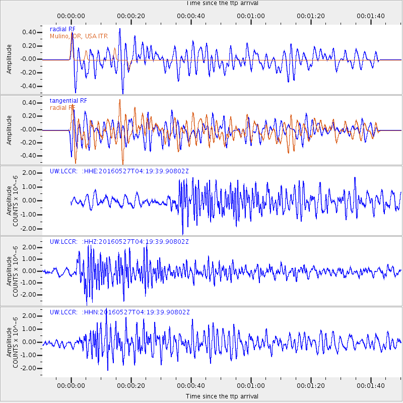
Signal To Noise
| Channel | StoN | STA | LTA |
| UW:LCCR: :HHZ:20160527T04:19:39.90802Z | 4.2303405 | 7.2563785E-7 | 1.7153178E-7 |
| UW:LCCR: :HHN:20160527T04:19:39.90802Z | 1.1595665 | 2.5988044E-7 | 2.2411861E-7 |
| UW:LCCR: :HHE:20160527T04:19:39.90802Z | 0.80634755 | 2.4609108E-7 | 3.0519232E-7 |
| Arrivals |
| Ps | |
| PpPs | |
| PsPs/PpSs | |


