BW06 Boulder Array Site 6 (Pinedale), Wyoming, USA - Earthquake Result Viewer
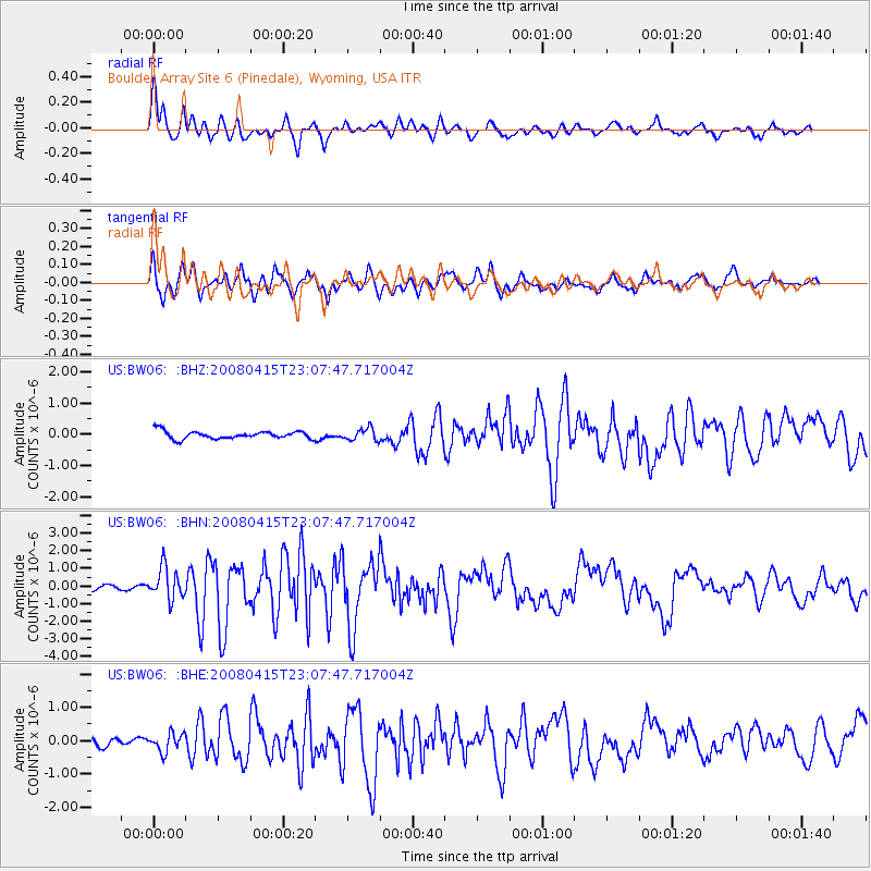
Earthquake location: Andreanof Islands, Aleutian Is.
Earthquake latitude/longitude: 51.9/-179.4
Earthquake time(UTC): 2008/04/15 (106) 22:59:51 GMT
Earthquake Depth: 10 km
Earthquake Magnitude: 6.1 MB, 6.4 MS, 6.4 MW, 6.4 MW
Earthquake Catalog/Contributor: WHDF/NEIC
Network: US United States National Seismic Network
Station: BW06 Boulder Array Site 6 (Pinedale), Wyoming, USA
Lat/Lon: 42.77 N/109.56 W
Elevation: 2224 m
Distance: 46.5 deg
Az: 72.33 deg
Baz: 306.629 deg
Ray Param: 0.070608646
Estimated Moho Depth: 50.0 km
Estimated Crust Vp/Vs: 1.69
Assumed Crust Vp: 6.161 km/s
Estimated Crust Vs: 3.651 km/s
Estimated Crust Poisson's Ratio: 0.23
Radial Match: 91.39475 %
Radial Bump: 400
Transverse Match: 85.63783 %
Transverse Bump: 400
SOD ConfigId: 2504
Insert Time: 2010-03-05 03:39:32.675 +0000
GWidth: 2.5
Max Bumps: 400
Tol: 0.001

Signal To Noise

ChannelStoNSTALTA
US:BW06: :BHN:20080415T23:07:47.717004Z7.6471098.931865E-71.1680054E-7
US:BW06: :BHE:20080415T23:07:47.717004Z2.58833932.754418E-71.06416415E-7
US:BW06: :BHZ:20080415T23:07:47.717004Z1.58020371.9321143E-71.2226997E-7
Arrivals
Ps5.9 SECOND
PpPs21 SECOND
PsPs/PpSs26 SECOND