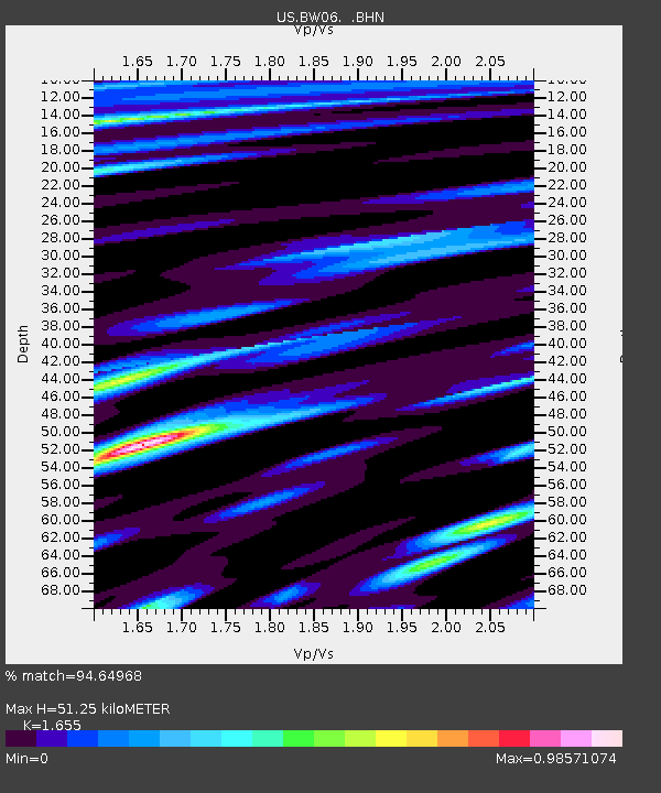
BW06 Boulder Array Site 6 (Pinedale), Wyoming, USA - Earthquake Result Viewer
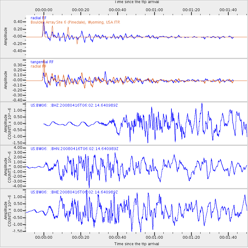
Earthquake location: Andreanof Islands, Aleutian Is.
Earthquake latitude/longitude: 51.9/-179.2
Earthquake time(UTC): 2008/04/16 (107) 05:54:19 GMT
Earthquake Depth: 13 km
Earthquake Magnitude: 6.1 MB, 6.5 MS, 6.6 MW, 6.6 MW
Earthquake Catalog/Contributor: WHDF/NEIC
Network: US United States National Seismic Network
Station: BW06 Boulder Array Site 6 (Pinedale), Wyoming, USA
Lat/Lon: 42.77 N/109.56 W
Elevation: 2224 m
Distance: 46.4 deg
Az: 72.469 deg
Baz: 306.61 deg
Ray Param: 0.0706763
Estimated Moho Depth: 51.25 km
Estimated Crust Vp/Vs: 1.65
Assumed Crust Vp: 6.161 km/s
Estimated Crust Vs: 3.723 km/s
Estimated Crust Poisson's Ratio: 0.21
Radial Match: 94.64968 %
Radial Bump: 400
Transverse Match: 91.18966 %
Transverse Bump: 400
SOD ConfigId: 2504
Insert Time: 2010-03-05 03:39:37.953 +0000
GWidth: 2.5
Max Bumps: 400
Tol: 0.001

Signal To Noise

ChannelStoNSTALTA
US:BW06: :BHN:20080416T06:02:14.640989Z3.37928874.720065E-71.3967629E-7
US:BW06: :BHE:20080416T06:02:14.640989Z3.70771.9817988E-75.345089E-8
US:BW06: :BHZ:20080416T06:02:14.640989Z0.867502758.726632E-81.0059487E-7
Arrivals
Ps5.8 SECOND
PpPs21 SECOND
PsPs/PpSs27 SECOND