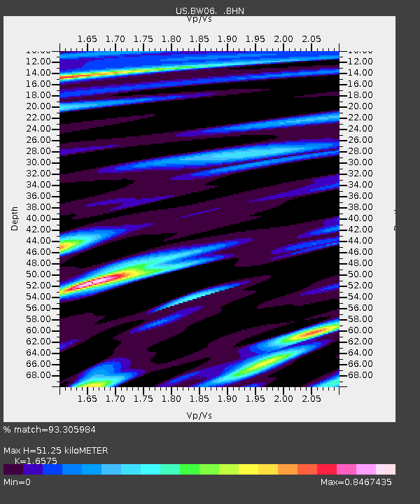
BW06 Boulder Array Site 6 (Pinedale), Wyoming, USA - Earthquake Result Viewer
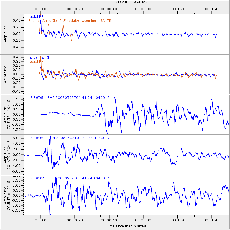
Earthquake location: Andreanof Islands, Aleutian Is.
Earthquake latitude/longitude: 51.9/-177.5
Earthquake time(UTC): 2008/05/02 (123) 01:33:37 GMT
Earthquake Depth: 14 km
Earthquake Magnitude: 6.3 MB, 6.8 MS, 6.6 MW, 6.6 MW
Earthquake Catalog/Contributor: WHDF/NEIC
Network: US United States National Seismic Network
Station: BW06 Boulder Array Site 6 (Pinedale), Wyoming, USA
Lat/Lon: 42.77 N/109.56 W
Elevation: 2224 m
Distance: 45.4 deg
Az: 73.452 deg
Baz: 306.177 deg
Ray Param: 0.07128722
Estimated Moho Depth: 51.25 km
Estimated Crust Vp/Vs: 1.66
Assumed Crust Vp: 6.161 km/s
Estimated Crust Vs: 3.717 km/s
Estimated Crust Poisson's Ratio: 0.21
Radial Match: 93.305984 %
Radial Bump: 400
Transverse Match: 89.94986 %
Transverse Bump: 400
SOD ConfigId: 2504
Insert Time: 2010-03-05 03:39:45.431 +0000
GWidth: 2.5
Max Bumps: 400
Tol: 0.001

Signal To Noise

ChannelStoNSTALTA
US:BW06: :BHN:20080502T01:41:24.404001Z19.7780271.2141619E-66.1389436E-8
US:BW06: :BHE:20080502T01:41:24.404001Z1.84610212.8557744E-71.5469212E-7
US:BW06: :BHZ:20080502T01:41:24.404001Z2.7395452.3458551E-78.562937E-8
Arrivals
Ps5.8 SECOND
PpPs21 SECOND
PsPs/PpSs27 SECOND