You are here: Home > Network List > AK - Alaska Regional Network Stations List
> Station YAH Yahtse, AK, USA > Earthquake Result Viewer
YAH Yahtse, AK, USA - Earthquake Result Viewer
| Earthquake location: |
South Of Fiji Islands |
| Earthquake latitude/longitude: |
-22.0/-178.2 |
| Earthquake time(UTC): |
2016/05/28 (149) 05:38:51 GMT |
| Earthquake Depth: |
417 km |
| Earthquake Magnitude: |
6.6 MO |
| Earthquake Catalog/Contributor: |
NEIC PDE/NEIC ALERT |
|
| Network: |
AK Alaska Regional Network |
| Station: |
YAH Yahtse, AK, USA |
| Lat/Lon: |
60.36 N/141.75 W |
| Elevation: |
2125 m |
|
| Distance: |
87.3 deg |
| Az: |
17.181 deg |
| Baz: |
213.463 deg |
| Ray Param: |
0.042355742 |
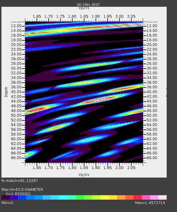
| Estimated Moho Depth: |
43.0 km |
| Estimated Crust Vp/Vs: |
1.92 |
| Assumed Crust Vp: |
6.566 km/s |
| Estimated Crust Vs: |
3.42 km/s |
| Estimated Crust Poisson's Ratio: |
0.31 |
|
| Radial Match: |
91.15297 % |
| Radial Bump: |
400 |
| Transverse Match: |
84.54457 % |
| Transverse Bump: |
400 |
| SOD ConfigId: |
7422571 |
| Insert Time: |
2019-04-22 16:21:01.304 +0000 |
| GWidth: |
2.5 |
| Max Bumps: |
400 |
| Tol: |
0.001 |
|

Signal To Noise
| Channel | StoN | STA | LTA |
| AK:YAH: :BHZ:20160528T05:50:21.088013Z | 97.400894 | 7.930138E-6 | 8.1417504E-8 |
| AK:YAH: :BHN:20160528T05:50:21.088013Z | 24.392122 | 1.9170047E-6 | 7.8591135E-8 |
| AK:YAH: :BHE:20160528T05:50:21.088013Z | 35.602516 | 2.1376625E-6 | 6.004246E-8 |
| Arrivals |
| Ps | 6.2 SECOND |
| PpPs | 19 SECOND |
| PsPs/PpSs | 25 SECOND |


