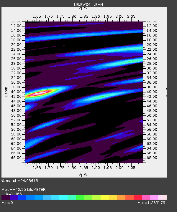
BW06 Boulder Array Site 6 (Pinedale), Wyoming, USA - Earthquake Result Viewer
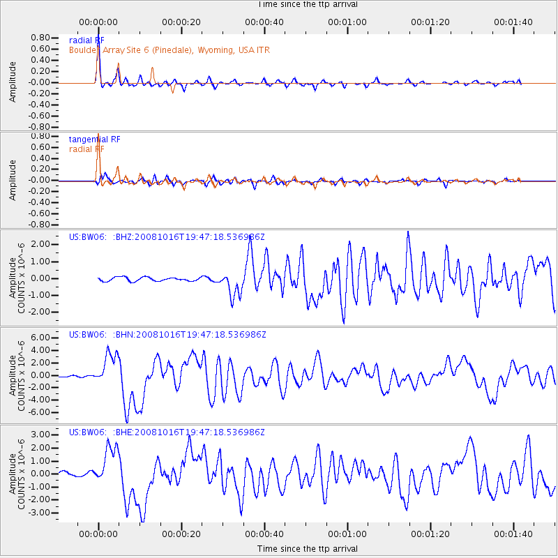
Earthquake location: Near Coast Of Chiapas, Mexico
Earthquake latitude/longitude: 14.4/-92.4
Earthquake time(UTC): 2008/10/16 (290) 19:41:25 GMT
Earthquake Depth: 24 km
Earthquake Magnitude: 6.1 MB, 6.6 MS, 6.7 MW, 6.6 MW
Earthquake Catalog/Contributor: WHDF/NEIC
Network: US United States National Seismic Network
Station: BW06 Boulder Array Site 6 (Pinedale), Wyoming, USA
Lat/Lon: 42.77 N/109.56 W
Elevation: 2224 m
Distance: 31.9 deg
Az: 335.667 deg
Baz: 147.171 deg
Ray Param: 0.078855135
Estimated Moho Depth: 40.25 km
Estimated Crust Vp/Vs: 1.66
Assumed Crust Vp: 6.161 km/s
Estimated Crust Vs: 3.7 km/s
Estimated Crust Poisson's Ratio: 0.22
Radial Match: 94.08618 %
Radial Bump: 330
Transverse Match: 84.649055 %
Transverse Bump: 400
SOD ConfigId: 2556
Insert Time: 2010-03-05 03:40:03.436 +0000
GWidth: 2.5
Max Bumps: 400
Tol: 0.001

Signal To Noise

ChannelStoNSTALTA
US:BW06: :BHN:20081016T19:47:18.536986Z14.9512122.7289475E-61.825235E-7
US:BW06: :BHE:20081016T19:47:18.536986Z9.2153011.5759116E-61.7101033E-7
US:BW06: :BHZ:20081016T19:47:18.536986Z6.71485767.455456E-71.1102925E-7
Arrivals
Ps4.7 SECOND
PpPs16 SECOND
PsPs/PpSs21 SECOND