You are here: Home > Network List > C1 - Red Sismologica Nacional Stations List
> Station MT01 Daracena > Earthquake Result Viewer
MT01 Daracena - Earthquake Result Viewer
| Earthquake location: |
South Of Fiji Islands |
| Earthquake latitude/longitude: |
-22.0/-178.2 |
| Earthquake time(UTC): |
2016/05/28 (149) 05:38:51 GMT |
| Earthquake Depth: |
417 km |
| Earthquake Magnitude: |
6.6 MO |
| Earthquake Catalog/Contributor: |
NEIC PDE/NEIC ALERT |
|
| Network: |
C1 Red Sismologica Nacional |
| Station: |
MT01 Daracena |
| Lat/Lon: |
33.86 S/71.25 W |
| Elevation: |
310 m |
|
| Distance: |
91.0 deg |
| Az: |
127.228 deg |
| Baz: |
242.615 deg |
| Ray Param: |
0.041452523 |
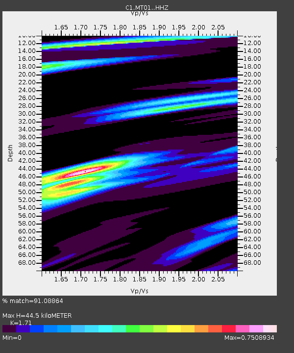
| Estimated Moho Depth: |
44.5 km |
| Estimated Crust Vp/Vs: |
1.71 |
| Assumed Crust Vp: |
6.481 km/s |
| Estimated Crust Vs: |
3.79 km/s |
| Estimated Crust Poisson's Ratio: |
0.24 |
|
| Radial Match: |
91.08864 % |
| Radial Bump: |
357 |
| Transverse Match: |
69.280075 % |
| Transverse Bump: |
400 |
| SOD ConfigId: |
7422571 |
| Insert Time: |
2019-04-22 16:22:35.237 +0000 |
| GWidth: |
2.5 |
| Max Bumps: |
400 |
| Tol: |
0.001 |
|

Signal To Noise
| Channel | StoN | STA | LTA |
| C1:MT01: :HHZ:20160528T05:50:38.940002Z | 7.264402 | 9.728942E-7 | 1.3392626E-7 |
| C1:MT01: :HHN:20160528T05:50:38.940002Z | 1.2435691 | 9.8723014E-8 | 7.938682E-8 |
| C1:MT01: :HHE:20160528T05:50:38.940002Z | 4.5476785 | 3.7253542E-7 | 8.191771E-8 |
| Arrivals |
| Ps | 5.0 SECOND |
| PpPs | 18 SECOND |
| PsPs/PpSs | 23 SECOND |


