You are here: Home > Network List > US - United States National Seismic Network Stations List
> Station BW06 Boulder Array Site 6 (Pinedale), Wyoming, USA > Earthquake Result Viewer
BW06 Boulder Array Site 6 (Pinedale), Wyoming, USA - Earthquake Result Viewer
| Earthquake location: |
Northern Mid-Atlantic Ridge |
| Earthquake latitude/longitude: |
10.8/-42.3 |
| Earthquake time(UTC): |
1996/06/02 (154) 02:52:09 GMT |
| Earthquake Depth: |
10 km |
| Earthquake Magnitude: |
6.1 MB, 6.9 MS, 7.0 UNKNOWN, 6.8 MW |
| Earthquake Catalog/Contributor: |
WHDF/NEIC |
|
| Network: |
US United States National Seismic Network |
| Station: |
BW06 Boulder Array Site 6 (Pinedale), Wyoming, USA |
| Lat/Lon: |
42.77 N/109.56 W |
| Elevation: |
2224 m |
|
| Distance: |
66.1 deg |
| Az: |
312.007 deg |
| Baz: |
97.505 deg |
| Ray Param: |
0.057835124 |
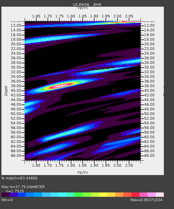
| Estimated Moho Depth: |
37.75 km |
| Estimated Crust Vp/Vs: |
1.75 |
| Assumed Crust Vp: |
6.161 km/s |
| Estimated Crust Vs: |
3.515 km/s |
| Estimated Crust Poisson's Ratio: |
0.26 |
|
| Radial Match: |
93.44658 % |
| Radial Bump: |
400 |
| Transverse Match: |
91.03716 % |
| Transverse Bump: |
400 |
| SOD ConfigId: |
110177 |
| Insert Time: |
2010-03-05 03:40:30.056 +0000 |
| GWidth: |
2.5 |
| Max Bumps: |
400 |
| Tol: |
0.001 |
|
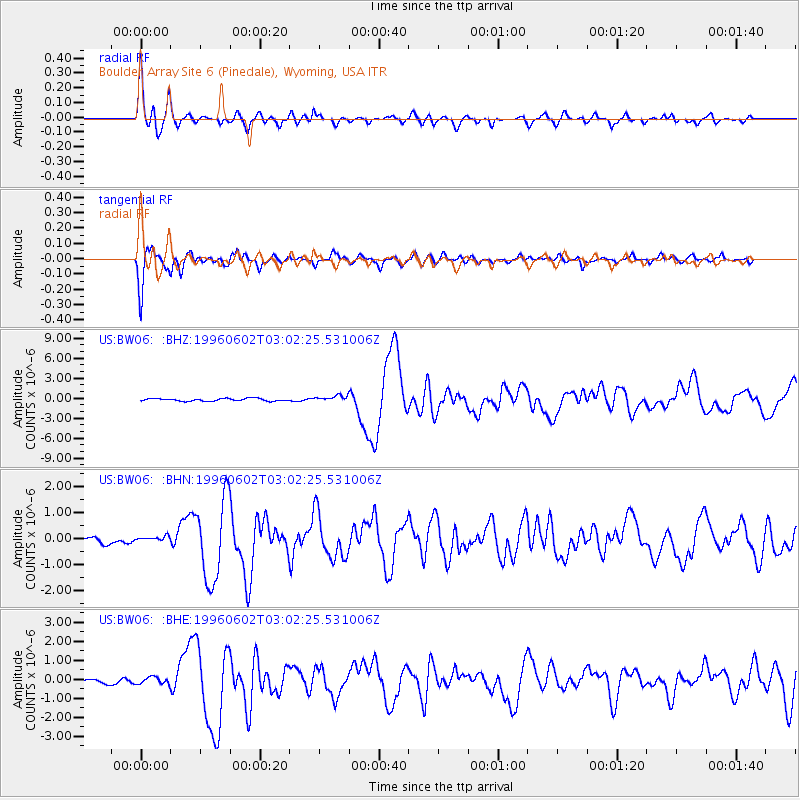
Signal To Noise
| Channel | StoN | STA | LTA |
| US:BW06: :BHN:19960602T03:02:25.531006Z | 0.9672127 | 1.02594136E-7 | 1.0607195E-7 |
| US:BW06: :BHE:19960602T03:02:25.531006Z | 1.5165371 | 1.7551632E-7 | 1.15734935E-7 |
| US:BW06: :BHZ:19960602T03:02:25.531006Z | 2.26797 | 4.6007247E-7 | 2.0285651E-7 |
| Arrivals |
| Ps | 4.8 SECOND |
| PpPs | 16 SECOND |
| PsPs/PpSs | 21 SECOND |


