You are here: Home > Network List > CB - China National Seismic Network Stations List
> Station TIA Taian,Shandong Province > Earthquake Result Viewer
TIA Taian,Shandong Province - Earthquake Result Viewer
| Earthquake location: |
South Of Fiji Islands |
| Earthquake latitude/longitude: |
-22.0/-178.2 |
| Earthquake time(UTC): |
2016/05/28 (149) 05:38:51 GMT |
| Earthquake Depth: |
417 km |
| Earthquake Magnitude: |
6.6 MO |
| Earthquake Catalog/Contributor: |
NEIC PDE/NEIC ALERT |
|
| Network: |
CB China National Seismic Network |
| Station: |
TIA Taian,Shandong Province |
| Lat/Lon: |
36.21 N/117.12 E |
| Elevation: |
267 m |
|
| Distance: |
84.2 deg |
| Az: |
312.689 deg |
| Baz: |
122.504 deg |
| Ray Param: |
0.04453226 |
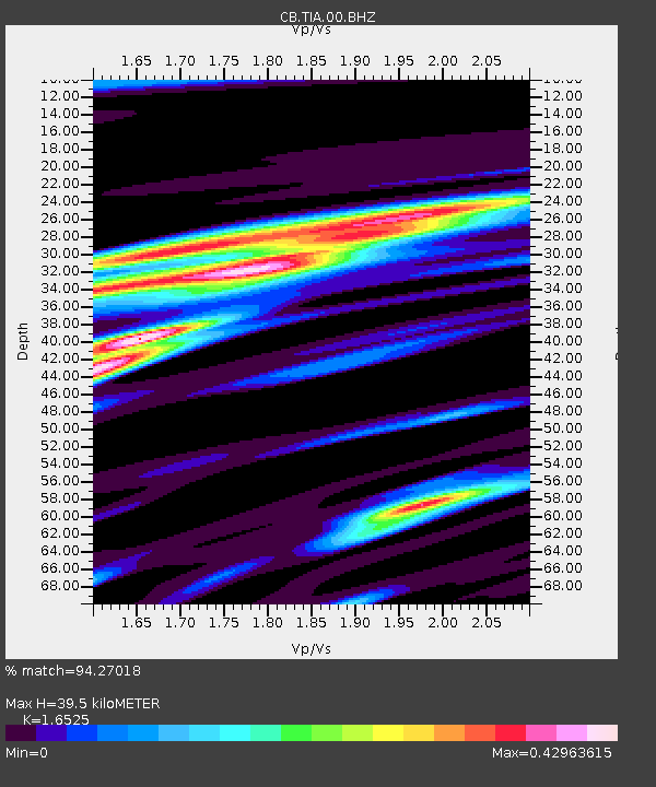
| Estimated Moho Depth: |
39.5 km |
| Estimated Crust Vp/Vs: |
1.65 |
| Assumed Crust Vp: |
6.363 km/s |
| Estimated Crust Vs: |
3.85 km/s |
| Estimated Crust Poisson's Ratio: |
0.21 |
|
| Radial Match: |
94.27018 % |
| Radial Bump: |
316 |
| Transverse Match: |
70.39527 % |
| Transverse Bump: |
400 |
| SOD ConfigId: |
7422571 |
| Insert Time: |
2019-04-22 16:22:49.351 +0000 |
| GWidth: |
2.5 |
| Max Bumps: |
400 |
| Tol: |
0.001 |
|

Signal To Noise
| Channel | StoN | STA | LTA |
| CB:TIA:00:BHZ:20160528T05:50:06.090027Z | 80.49676 | 9.1392485E-6 | 1.1353561E-7 |
| CB:TIA:00:BHN:20160528T05:50:06.090027Z | 53.476894 | 1.990449E-6 | 3.7220726E-8 |
| CB:TIA:00:BHE:20160528T05:50:06.090027Z | 42.50122 | 3.0523126E-6 | 7.1817055E-8 |
| Arrivals |
| Ps | 4.2 SECOND |
| PpPs | 16 SECOND |
| PsPs/PpSs | 20 SECOND |


