You are here: Home > Network List > CC - Cascade Chain Volcano Monitoring Stations List
> Station TMBU Tom Butte, Newberry, OR > Earthquake Result Viewer
TMBU Tom Butte, Newberry, OR - Earthquake Result Viewer
| Earthquake location: |
South Of Fiji Islands |
| Earthquake latitude/longitude: |
-22.0/-178.2 |
| Earthquake time(UTC): |
2016/05/28 (149) 05:38:51 GMT |
| Earthquake Depth: |
417 km |
| Earthquake Magnitude: |
6.6 MO |
| Earthquake Catalog/Contributor: |
NEIC PDE/NEIC ALERT |
|
| Network: |
CC Cascade Chain Volcano Monitoring |
| Station: |
TMBU Tom Butte, Newberry, OR |
| Lat/Lon: |
43.60 N/121.14 W |
| Elevation: |
1743 m |
|
| Distance: |
83.6 deg |
| Az: |
37.817 deg |
| Baz: |
231.552 deg |
| Ray Param: |
0.044914838 |
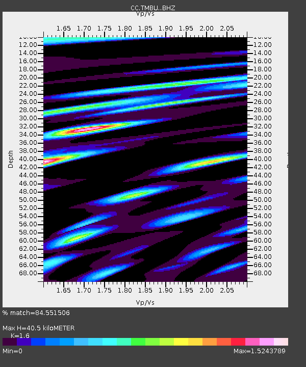
| Estimated Moho Depth: |
40.5 km |
| Estimated Crust Vp/Vs: |
1.60 |
| Assumed Crust Vp: |
6.597 km/s |
| Estimated Crust Vs: |
4.123 km/s |
| Estimated Crust Poisson's Ratio: |
0.18 |
|
| Radial Match: |
84.551506 % |
| Radial Bump: |
400 |
| Transverse Match: |
83.074875 % |
| Transverse Bump: |
400 |
| SOD ConfigId: |
7422571 |
| Insert Time: |
2019-04-22 16:23:02.941 +0000 |
| GWidth: |
2.5 |
| Max Bumps: |
400 |
| Tol: |
0.001 |
|

Signal To Noise
| Channel | StoN | STA | LTA |
| CC:TMBU: :BHZ:20160528T05:50:03.599976Z | 118.551155 | 1.1412407E-5 | 9.626568E-8 |
| CC:TMBU: :BHN:20160528T05:50:03.599976Z | 17.951744 | 2.6091393E-6 | 1.4534183E-7 |
| CC:TMBU: :BHE:20160528T05:50:03.599976Z | 11.4148 | 2.3498271E-6 | 2.0585793E-7 |
| Arrivals |
| Ps | 3.8 SECOND |
| PpPs | 16 SECOND |
| PsPs/PpSs | 19 SECOND |


