You are here: Home > Network List > JP - Japan Meteorological Agency Seismic Network Stations List
> Station JSU Kagoshima Suzuyama > Earthquake Result Viewer
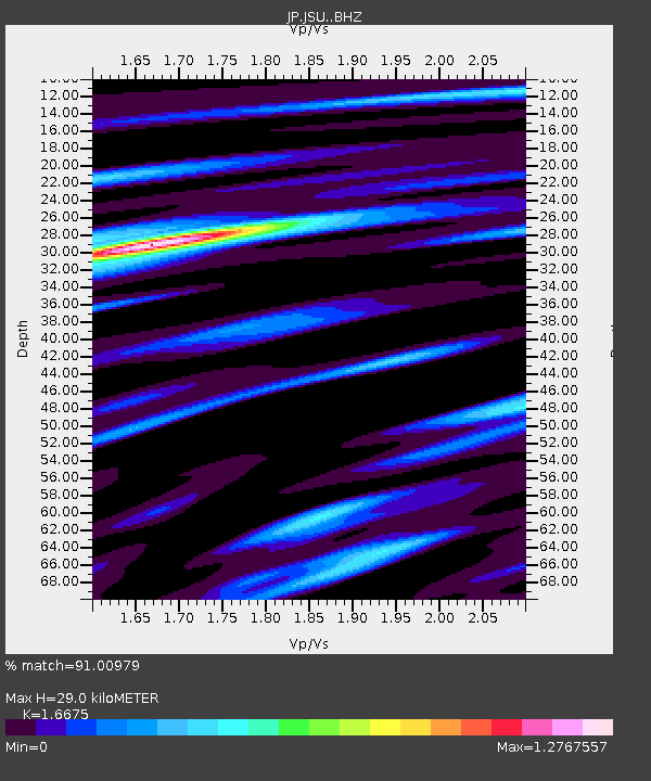
JSU Kagoshima Suzuyama - Earthquake Result Viewer
| Earthquake location: |
South Of Fiji Islands |
| Earthquake latitude/longitude: |
-22.0/-178.2 |
| Earthquake time(UTC): |
2016/05/28 (149) 05:38:51 GMT |
| Earthquake Depth: |
417 km |
| Earthquake Magnitude: |
6.6 MO |
| Earthquake Catalog/Contributor: |
NEIC PDE/NEIC ALERT |
|
| Network: |
JP Japan Meteorological Agency Seismic Network |
| Station: |
JSU Kagoshima Suzuyama |
| Lat/Lon: |
31.51 N/130.45 E |
| Elevation: |
400 m |
|
| Distance: |
72.5 deg |
| Az: |
315.591 deg |
| Baz: |
130.515 deg |
| Ray Param: |
0.052348386 |
| Estimated Moho Depth: |
29.0 km |
| Estimated Crust Vp/Vs: |
1.67 |
| Assumed Crust Vp: |
6.468 km/s |
| Estimated Crust Vs: |
3.879 km/s |
| Estimated Crust Poisson's Ratio: |
0.22 |
|
| Radial Match: |
91.00979 % |
| Radial Bump: |
380 |
| Transverse Match: |
84.43329 % |
| Transverse Bump: |
400 |
| SOD ConfigId: |
7422571 |
| Insert Time: |
2019-04-22 16:25:28.637 +0000 |
| GWidth: |
2.5 |
| Max Bumps: |
400 |
| Tol: |
0.001 |
|

Signal To Noise
| Channel | StoN | STA | LTA |
| JP:JSU: :BHZ:20160528T05:49:03.150024Z | 120.18359 | 1.0706718E-5 | 8.908635E-8 |
| JP:JSU: :BHN:20160528T05:49:03.150024Z | 27.129257 | 2.5821728E-6 | 9.5180376E-8 |
| JP:JSU: :BHE:20160528T05:49:03.150024Z | 33.02704 | 3.278813E-6 | 9.9276626E-8 |
| Arrivals |
| Ps | 3.1 SECOND |
| PpPs | 12 SECOND |
| PsPs/PpSs | 15 SECOND |


