You are here: Home > Network List > NN - Western Great Basin/Eastern Sierra Nevada Stations List
> Station CMK6 Chalk Mountain, Churchill County, NV, USA > Earthquake Result Viewer
CMK6 Chalk Mountain, Churchill County, NV, USA - Earthquake Result Viewer
| Earthquake location: |
South Of Fiji Islands |
| Earthquake latitude/longitude: |
-22.0/-178.2 |
| Earthquake time(UTC): |
2016/05/28 (149) 05:38:51 GMT |
| Earthquake Depth: |
417 km |
| Earthquake Magnitude: |
6.6 MO |
| Earthquake Catalog/Contributor: |
NEIC PDE/NEIC ALERT |
|
| Network: |
NN Western Great Basin/Eastern Sierra Nevada |
| Station: |
CMK6 Chalk Mountain, Churchill County, NV, USA |
| Lat/Lon: |
39.31 N/118.12 W |
| Elevation: |
1332 m |
|
| Distance: |
82.9 deg |
| Az: |
42.641 deg |
| Baz: |
234.117 deg |
| Ray Param: |
0.04545768 |
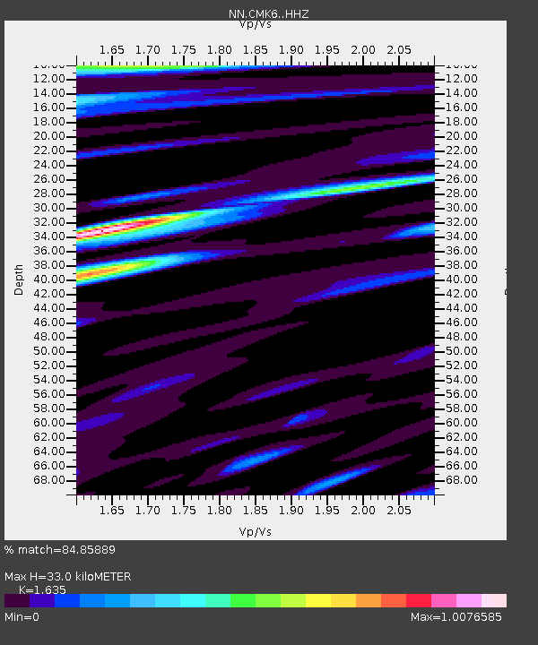
| Estimated Moho Depth: |
33.0 km |
| Estimated Crust Vp/Vs: |
1.63 |
| Assumed Crust Vp: |
6.279 km/s |
| Estimated Crust Vs: |
3.84 km/s |
| Estimated Crust Poisson's Ratio: |
0.20 |
|
| Radial Match: |
84.85889 % |
| Radial Bump: |
400 |
| Transverse Match: |
77.44902 % |
| Transverse Bump: |
400 |
| SOD ConfigId: |
7422571 |
| Insert Time: |
2019-04-22 16:25:54.826 +0000 |
| GWidth: |
2.5 |
| Max Bumps: |
400 |
| Tol: |
0.001 |
|

Signal To Noise
| Channel | StoN | STA | LTA |
| NN:CMK6: :HHZ:20160528T05:49:59.724976Z | 94.072945 | 3.2811786E-6 | 3.487909E-8 |
| NN:CMK6: :HHN:20160528T05:49:59.724976Z | 20.592161 | 6.3642767E-7 | 3.0906307E-8 |
| NN:CMK6: :HHE:20160528T05:49:59.724976Z | 26.398163 | 7.5323106E-7 | 2.8533465E-8 |
| Arrivals |
| Ps | 3.4 SECOND |
| PpPs | 13 SECOND |
| PsPs/PpSs | 17 SECOND |


