You are here: Home > Network List > US - United States National Seismic Network Stations List
> Station BW06 Boulder Array Site 6 (Pinedale), Wyoming, USA > Earthquake Result Viewer
BW06 Boulder Array Site 6 (Pinedale), Wyoming, USA - Earthquake Result Viewer
| Earthquake location: |
Tonga Islands Region |
| Earthquake latitude/longitude: |
-23.0/-174.7 |
| Earthquake time(UTC): |
2009/03/19 (078) 18:17:40 GMT |
| Earthquake Depth: |
34 km |
| Earthquake Magnitude: |
7.0 MB, 7.6 MS, 7.6 MW, 7.6 MW |
| Earthquake Catalog/Contributor: |
WHDF/NEIC |
|
| Network: |
US United States National Seismic Network |
| Station: |
BW06 Boulder Array Site 6 (Pinedale), Wyoming, USA |
| Lat/Lon: |
42.77 N/109.56 W |
| Elevation: |
2224 m |
|
| Distance: |
88.7 deg |
| Az: |
41.921 deg |
| Baz: |
236.691 deg |
| Ray Param: |
0.04232784 |
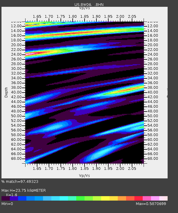
| Estimated Moho Depth: |
23.75 km |
| Estimated Crust Vp/Vs: |
1.60 |
| Assumed Crust Vp: |
6.161 km/s |
| Estimated Crust Vs: |
3.851 km/s |
| Estimated Crust Poisson's Ratio: |
0.18 |
|
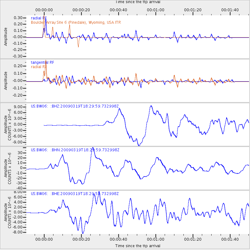
| Radial Match: |
97.49323 % |
| Radial Bump: |
400 |
| Transverse Match: |
86.78929 % |
| Transverse Bump: |
400 |
| SOD ConfigId: |
2658 |
| Insert Time: |
2010-03-05 03:42:15.687 +0000 |
| GWidth: |
2.5 |
| Max Bumps: |
400 |
| Tol: |
0.001 |
|
Signal To Noise
| Channel | StoN | STA | LTA |
| US:BW06: :BHN:20090319T18:29:59.732998Z | 16.737234 | 4.0889504E-6 | 2.4430264E-7 |
| US:BW06: :BHE:20090319T18:29:59.732998Z | 9.515493 | 6.7431677E-7 | 7.086514E-8 |
| US:BW06: :BHZ:20090319T18:29:59.732998Z | 13.867523 | 1.1084622E-6 | 7.993224E-8 |
| Arrivals |
| Ps | 2.4 SECOND |
| PpPs | 9.8 SECOND |
| PsPs/PpSs | 12 SECOND |


