You are here: Home > Network List > S - Seismographs in Schools Projects Stations List
> Station AULRC Lightning Ridge Central School, NSW, Australia > Earthquake Result Viewer
AULRC Lightning Ridge Central School, NSW, Australia - Earthquake Result Viewer
| Earthquake location: |
South Of Fiji Islands |
| Earthquake latitude/longitude: |
-22.0/-178.2 |
| Earthquake time(UTC): |
2016/05/28 (149) 05:38:51 GMT |
| Earthquake Depth: |
417 km |
| Earthquake Magnitude: |
6.6 MO |
| Earthquake Catalog/Contributor: |
NEIC PDE/NEIC ALERT |
|
| Network: |
S Seismographs in Schools Projects |
| Station: |
AULRC Lightning Ridge Central School, NSW, Australia |
| Lat/Lon: |
29.43 S/147.98 E |
| Elevation: |
145 m |
|
| Distance: |
31.3 deg |
| Az: |
249.317 deg |
| Baz: |
84.32 deg |
| Ray Param: |
0.07758099 |
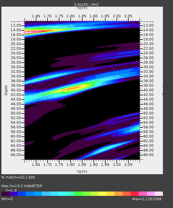
| Estimated Moho Depth: |
15.0 km |
| Estimated Crust Vp/Vs: |
1.60 |
| Assumed Crust Vp: |
6.522 km/s |
| Estimated Crust Vs: |
4.076 km/s |
| Estimated Crust Poisson's Ratio: |
0.18 |
|
| Radial Match: |
82.1385 % |
| Radial Bump: |
278 |
| Transverse Match: |
69.77801 % |
| Transverse Bump: |
374 |
| SOD ConfigId: |
7422571 |
| Insert Time: |
2019-04-22 16:27:30.472 +0000 |
| GWidth: |
2.5 |
| Max Bumps: |
400 |
| Tol: |
0.001 |
|

Signal To Noise
| Channel | StoN | STA | LTA |
| S:AULRC: :HHZ:20160528T05:44:04.630005Z | 19.25163 | 1.8335495E-5 | 9.5241256E-7 |
| S:AULRC: :HHN:20160528T05:44:04.630005Z | 2.241048 | 4.27315E-6 | 1.9067642E-6 |
| S:AULRC: :HHE:20160528T05:44:04.630005Z | 8.947511 | 1.069587E-5 | 1.1954018E-6 |
| Arrivals |
| Ps | 1.5 SECOND |
| PpPs | 5.5 SECOND |
| PsPs/PpSs | 7.0 SECOND |


