You are here: Home > Network List > TA - USArray Transportable Network (new EarthScope stations) Stations List
> Station 833A Chaparral WMA, Artesia Wells, TX, USA > Earthquake Result Viewer
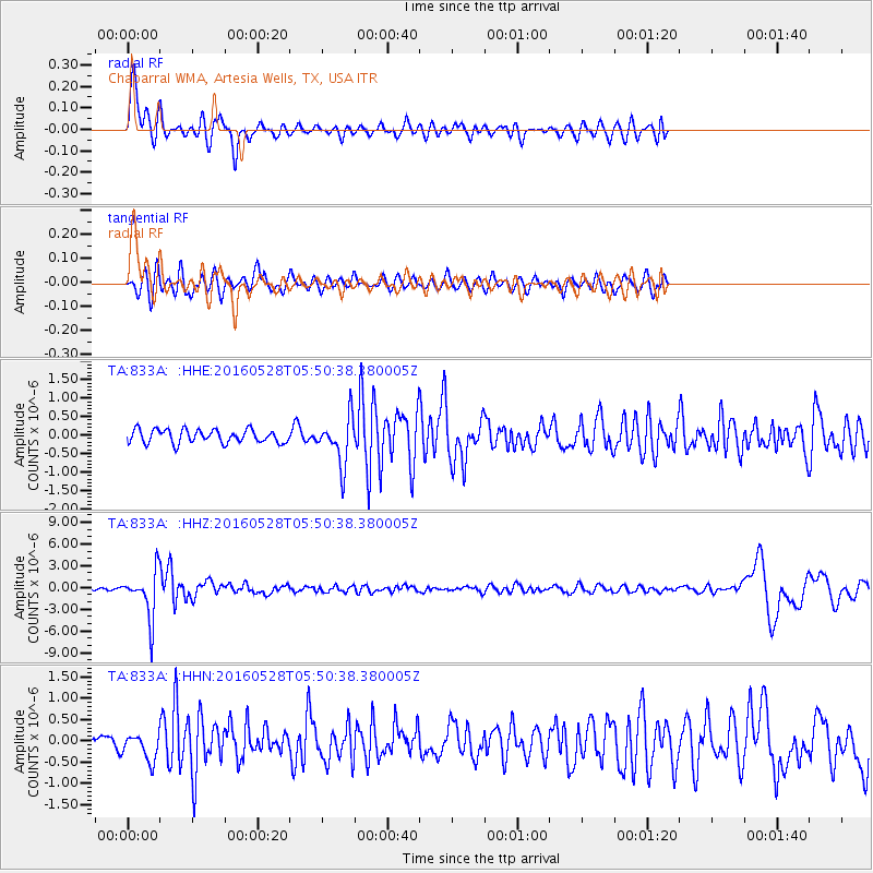
833A Chaparral WMA, Artesia Wells, TX, USA - Earthquake Result Viewer
*The percent match for this event was below the threshold and hence no stack was calculated.
| Earthquake location: |
South Of Fiji Islands |
| Earthquake latitude/longitude: |
-22.0/-178.2 |
| Earthquake time(UTC): |
2016/05/28 (149) 05:38:51 GMT |
| Earthquake Depth: |
417 km |
| Earthquake Magnitude: |
6.6 MO |
| Earthquake Catalog/Contributor: |
NEIC PDE/NEIC ALERT |
|
| Network: |
TA USArray Transportable Network (new EarthScope stations) |
| Station: |
833A Chaparral WMA, Artesia Wells, TX, USA |
| Lat/Lon: |
28.32 N/99.39 W |
| Elevation: |
171 m |
|
| Distance: |
91.0 deg |
| Az: |
59.864 deg |
| Baz: |
245.542 deg |
| Ray Param: |
$rayparam |
*The percent match for this event was below the threshold and hence was not used in the summary stack. |
|
| Radial Match: |
75.33416 % |
| Radial Bump: |
399 |
| Transverse Match: |
59.2127 % |
| Transverse Bump: |
378 |
| SOD ConfigId: |
7422571 |
| Insert Time: |
2019-04-22 16:27:55.304 +0000 |
| GWidth: |
2.5 |
| Max Bumps: |
400 |
| Tol: |
0.001 |
|
Signal To Noise
| Channel | StoN | STA | LTA |
| TA:833A: :HHZ:20160528T05:50:38.380005Z | 14.10433 | 3.278624E-6 | 2.3245514E-7 |
| TA:833A: :HHN:20160528T05:50:38.380005Z | 2.470439 | 3.070093E-7 | 1.2427317E-7 |
| TA:833A: :HHE:20160528T05:50:38.380005Z | 3.1554031 | 5.700185E-7 | 1.806484E-7 |
| Arrivals |
| Ps | |
| PpPs | |
| PsPs/PpSs | |


