You are here: Home > Network List > TA - USArray Transportable Network (new EarthScope stations) Stations List
> Station D03D Eldon, WA, USA > Earthquake Result Viewer
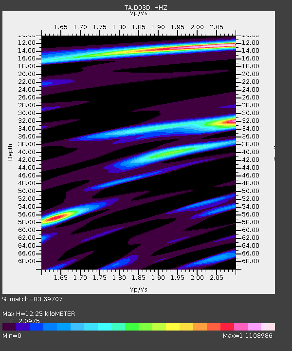
D03D Eldon, WA, USA - Earthquake Result Viewer
| Earthquake location: |
South Of Fiji Islands |
| Earthquake latitude/longitude: |
-22.0/-178.2 |
| Earthquake time(UTC): |
2016/05/28 (149) 05:38:51 GMT |
| Earthquake Depth: |
417 km |
| Earthquake Magnitude: |
6.6 MO |
| Earthquake Catalog/Contributor: |
NEIC PDE/NEIC ALERT |
|
| Network: |
TA USArray Transportable Network (new EarthScope stations) |
| Station: |
D03D Eldon, WA, USA |
| Lat/Lon: |
47.53 N/123.09 W |
| Elevation: |
262 m |
|
| Distance: |
85.1 deg |
| Az: |
33.89 deg |
| Baz: |
229.781 deg |
| Ray Param: |
0.04391731 |
| Estimated Moho Depth: |
12.25 km |
| Estimated Crust Vp/Vs: |
2.10 |
| Assumed Crust Vp: |
6.566 km/s |
| Estimated Crust Vs: |
3.13 km/s |
| Estimated Crust Poisson's Ratio: |
0.35 |
|
| Radial Match: |
83.69707 % |
| Radial Bump: |
388 |
| Transverse Match: |
87.291595 % |
| Transverse Bump: |
372 |
| SOD ConfigId: |
7422571 |
| Insert Time: |
2019-04-22 16:27:57.755 +0000 |
| GWidth: |
2.5 |
| Max Bumps: |
400 |
| Tol: |
0.001 |
|

Signal To Noise
| Channel | StoN | STA | LTA |
| TA:D03D: :HHZ:20160528T05:50:10.669983Z | 90.149254 | 6.136993E-6 | 6.807591E-8 |
| TA:D03D: :HHN:20160528T05:50:10.669983Z | 36.23274 | 1.6276858E-6 | 4.492307E-8 |
| TA:D03D: :HHE:20160528T05:50:10.669983Z | 19.451096 | 9.237365E-7 | 4.7490204E-8 |
| Arrivals |
| Ps | 2.1 SECOND |
| PpPs | 5.7 SECOND |
| PsPs/PpSs | 7.8 SECOND |


