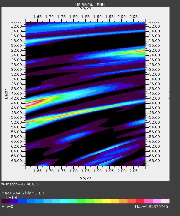
BW06 Boulder Array Site 6 (Pinedale), Wyoming, USA - Earthquake Result Viewer
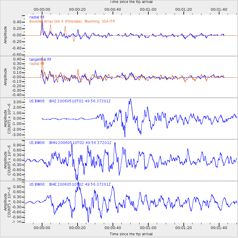
Earthquake location: Fox Islands, Aleutian Islands
Earthquake latitude/longitude: 52.5/-169.3
Earthquake time(UTC): 2006/05/10 (130) 02:42:51 GMT
Earthquake Depth: 18 km
Earthquake Magnitude: 6.1 MB, 6.2 MS, 6.4 MW, 6.3 MW
Earthquake Catalog/Contributor: WHDF/NEIC
Network: US United States National Seismic Network
Station: BW06 Boulder Array Site 6 (Pinedale), Wyoming, USA
Lat/Lon: 42.77 N/109.56 W
Elevation: 2224 m
Distance: 40.3 deg
Az: 79.367 deg
Baz: 305.349 deg
Ray Param: 0.074454054
Estimated Moho Depth: 44.5 km
Estimated Crust Vp/Vs: 1.60
Assumed Crust Vp: 6.161 km/s
Estimated Crust Vs: 3.851 km/s
Estimated Crust Poisson's Ratio: 0.18
Radial Match: 92.48415 %
Radial Bump: 400
Transverse Match: 88.21198 %
Transverse Bump: 400
SOD ConfigId: 2669
Insert Time: 2010-03-05 03:43:37.063 +0000
GWidth: 2.5
Max Bumps: 400
Tol: 0.001

Signal To Noise

ChannelStoNSTALTA
US:BW06: :BHN:20060510T02:49:56.37201Z2.15054681.8103087E-78.4179E-8
US:BW06: :BHE:20060510T02:49:56.37201Z4.60277842.5563392E-75.5539044E-8
US:BW06: :BHZ:20060510T02:49:56.37201Z5.85804274.7573522E-78.121061E-8
Arrivals
Ps4.7 SECOND
PpPs17 SECOND
PsPs/PpSs22 SECOND