You are here: Home > Network List > TA - USArray Transportable Network (new EarthScope stations) Stations List
> Station K20K Telida, AK, USA > Earthquake Result Viewer
K20K Telida, AK, USA - Earthquake Result Viewer
| Earthquake location: |
South Of Fiji Islands |
| Earthquake latitude/longitude: |
-22.0/-178.2 |
| Earthquake time(UTC): |
2016/05/28 (149) 05:38:51 GMT |
| Earthquake Depth: |
417 km |
| Earthquake Magnitude: |
6.6 MO |
| Earthquake Catalog/Contributor: |
NEIC PDE/NEIC ALERT |
|
| Network: |
TA USArray Transportable Network (new EarthScope stations) |
| Station: |
K20K Telida, AK, USA |
| Lat/Lon: |
63.36 N/154.07 W |
| Elevation: |
548 m |
|
| Distance: |
87.2 deg |
| Az: |
10.617 deg |
| Baz: |
202.285 deg |
| Ray Param: |
0.042414308 |
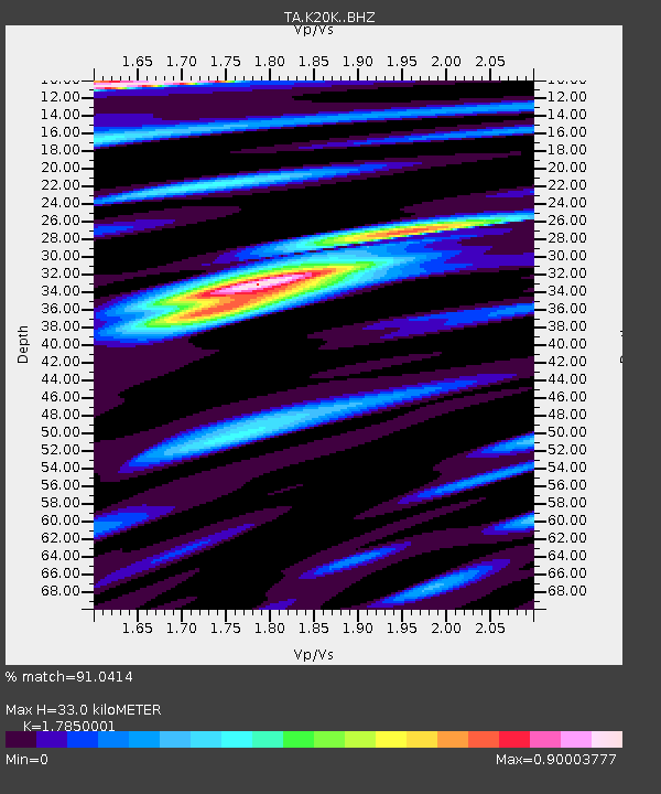
| Estimated Moho Depth: |
33.0 km |
| Estimated Crust Vp/Vs: |
1.79 |
| Assumed Crust Vp: |
6.438 km/s |
| Estimated Crust Vs: |
3.607 km/s |
| Estimated Crust Poisson's Ratio: |
0.27 |
|
| Radial Match: |
91.0414 % |
| Radial Bump: |
400 |
| Transverse Match: |
86.35961 % |
| Transverse Bump: |
400 |
| SOD ConfigId: |
7422571 |
| Insert Time: |
2019-04-22 16:28:24.294 +0000 |
| GWidth: |
2.5 |
| Max Bumps: |
400 |
| Tol: |
0.001 |
|

Signal To Noise
| Channel | StoN | STA | LTA |
| TA:K20K: :BHZ:20160528T05:50:20.674988Z | 119.336945 | 6.6605576E-6 | 5.5813043E-8 |
| TA:K20K: :BHN:20160528T05:50:20.674988Z | 33.638542 | 1.5386192E-6 | 4.573977E-8 |
| TA:K20K: :BHE:20160528T05:50:20.674988Z | 14.129138 | 7.0745597E-7 | 5.0070707E-8 |
| Arrivals |
| Ps | 4.1 SECOND |
| PpPs | 14 SECOND |
| PsPs/PpSs | 18 SECOND |


