You are here: Home > Network List > TA - USArray Transportable Network (new EarthScope stations) Stations List
> Station L20K Farewell, AK, USA > Earthquake Result Viewer
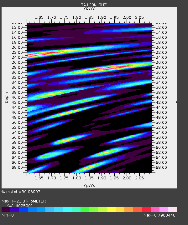
L20K Farewell, AK, USA - Earthquake Result Viewer
| Earthquake location: |
South Of Fiji Islands |
| Earthquake latitude/longitude: |
-22.0/-178.2 |
| Earthquake time(UTC): |
2016/05/28 (149) 05:38:51 GMT |
| Earthquake Depth: |
417 km |
| Earthquake Magnitude: |
6.6 MO |
| Earthquake Catalog/Contributor: |
NEIC PDE/NEIC ALERT |
|
| Network: |
TA USArray Transportable Network (new EarthScope stations) |
| Station: |
L20K Farewell, AK, USA |
| Lat/Lon: |
62.48 N/153.88 W |
| Elevation: |
673 m |
|
| Distance: |
86.4 deg |
| Az: |
11.034 deg |
| Baz: |
202.477 deg |
| Ray Param: |
0.042979 |
| Estimated Moho Depth: |
23.0 km |
| Estimated Crust Vp/Vs: |
1.60 |
| Assumed Crust Vp: |
6.566 km/s |
| Estimated Crust Vs: |
4.097 km/s |
| Estimated Crust Poisson's Ratio: |
0.18 |
|
| Radial Match: |
90.05097 % |
| Radial Bump: |
400 |
| Transverse Match: |
79.78116 % |
| Transverse Bump: |
400 |
| SOD ConfigId: |
7422571 |
| Insert Time: |
2019-04-22 16:28:31.729 +0000 |
| GWidth: |
2.5 |
| Max Bumps: |
400 |
| Tol: |
0.001 |
|

Signal To Noise
| Channel | StoN | STA | LTA |
| TA:L20K: :BHZ:20160528T05:50:16.974976Z | 110.646965 | 6.2299323E-6 | 5.6304593E-8 |
| TA:L20K: :BHN:20160528T05:50:16.974976Z | 34.234833 | 1.4885745E-6 | 4.3481286E-8 |
| TA:L20K: :BHE:20160528T05:50:16.974976Z | 36.741802 | 1.7291951E-6 | 4.7063427E-8 |
| Arrivals |
| Ps | 2.2 SECOND |
| PpPs | 8.9 SECOND |
| PsPs/PpSs | 11 SECOND |


