You are here: Home > Network List > TA - USArray Transportable Network (new EarthScope stations) Stations List
> Station TPFO Pinon Flats, CA, USA > Earthquake Result Viewer
TPFO Pinon Flats, CA, USA - Earthquake Result Viewer
| Earthquake location: |
South Of Fiji Islands |
| Earthquake latitude/longitude: |
-22.0/-178.2 |
| Earthquake time(UTC): |
2016/05/28 (149) 05:38:51 GMT |
| Earthquake Depth: |
417 km |
| Earthquake Magnitude: |
6.6 MO |
| Earthquake Catalog/Contributor: |
NEIC PDE/NEIC ALERT |
|
| Network: |
TA USArray Transportable Network (new EarthScope stations) |
| Station: |
TPFO Pinon Flats, CA, USA |
| Lat/Lon: |
33.61 N/116.45 W |
| Elevation: |
1275 m |
|
| Distance: |
80.7 deg |
| Az: |
48.13 deg |
| Baz: |
235.889 deg |
| Ray Param: |
0.04693461 |
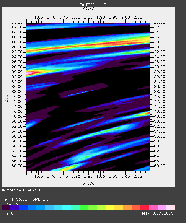
| Estimated Moho Depth: |
30.25 km |
| Estimated Crust Vp/Vs: |
1.60 |
| Assumed Crust Vp: |
6.264 km/s |
| Estimated Crust Vs: |
3.915 km/s |
| Estimated Crust Poisson's Ratio: |
0.18 |
|
| Radial Match: |
89.48798 % |
| Radial Bump: |
400 |
| Transverse Match: |
73.156105 % |
| Transverse Bump: |
400 |
| SOD ConfigId: |
7422571 |
| Insert Time: |
2019-04-22 16:29:02.773 +0000 |
| GWidth: |
2.5 |
| Max Bumps: |
400 |
| Tol: |
0.001 |
|
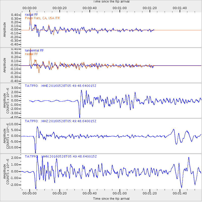
Signal To Noise
| Channel | StoN | STA | LTA |
| TA:TPFO: :HHZ:20160528T05:49:48.640015Z | 36.08861 | 4.7802164E-6 | 1.3245774E-7 |
| TA:TPFO: :HHN:20160528T05:49:48.640015Z | 13.230453 | 9.0938255E-7 | 6.873405E-8 |
| TA:TPFO: :HHE:20160528T05:49:48.640015Z | 13.70436 | 1.3157879E-6 | 9.601236E-8 |
| Arrivals |
| Ps | 3.0 SECOND |
| PpPs | 12 SECOND |
| PsPs/PpSs | 15 SECOND |


