You are here: Home > Network List > UW - Pacific Northwest Regional Seismic Network Stations List
> Station DDRF Dider Farm, Eltopia, WA, USA > Earthquake Result Viewer
DDRF Dider Farm, Eltopia, WA, USA - Earthquake Result Viewer
| Earthquake location: |
South Of Fiji Islands |
| Earthquake latitude/longitude: |
-22.0/-178.2 |
| Earthquake time(UTC): |
2016/05/28 (149) 05:38:51 GMT |
| Earthquake Depth: |
417 km |
| Earthquake Magnitude: |
6.6 MO |
| Earthquake Catalog/Contributor: |
NEIC PDE/NEIC ALERT |
|
| Network: |
UW Pacific Northwest Regional Seismic Network |
| Station: |
DDRF Dider Farm, Eltopia, WA, USA |
| Lat/Lon: |
46.49 N/119.06 W |
| Elevation: |
233 m |
|
| Distance: |
86.6 deg |
| Az: |
36.434 deg |
| Baz: |
232.906 deg |
| Ray Param: |
0.04285178 |
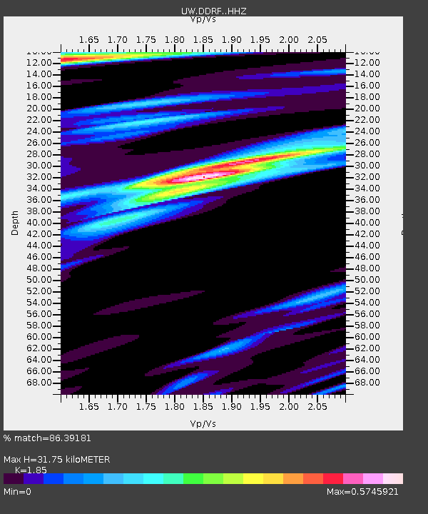
| Estimated Moho Depth: |
31.75 km |
| Estimated Crust Vp/Vs: |
1.85 |
| Assumed Crust Vp: |
6.419 km/s |
| Estimated Crust Vs: |
3.47 km/s |
| Estimated Crust Poisson's Ratio: |
0.29 |
|
| Radial Match: |
86.39181 % |
| Radial Bump: |
400 |
| Transverse Match: |
74.23083 % |
| Transverse Bump: |
400 |
| SOD ConfigId: |
7422571 |
| Insert Time: |
2019-04-22 16:29:43.831 +0000 |
| GWidth: |
2.5 |
| Max Bumps: |
400 |
| Tol: |
0.001 |
|

Signal To Noise
| Channel | StoN | STA | LTA |
| UW:DDRF: :HHZ:20160528T05:50:17.91803Z | 138.95241 | 9.107869E-6 | 6.554668E-8 |
| UW:DDRF: :HHN:20160528T05:50:17.91803Z | 32.50749 | 1.6052182E-6 | 4.9379956E-8 |
| UW:DDRF: :HHE:20160528T05:50:17.91803Z | 30.78393 | 1.3790967E-6 | 4.479924E-8 |
| Arrivals |
| Ps | 4.3 SECOND |
| PpPs | 14 SECOND |
| PsPs/PpSs | 18 SECOND |


