You are here: Home > Network List > UW - Pacific Northwest Regional Seismic Network Stations List
> Station YACT Amboy, WA, USA > Earthquake Result Viewer
YACT Amboy, WA, USA - Earthquake Result Viewer
| Earthquake location: |
South Of Fiji Islands |
| Earthquake latitude/longitude: |
-22.0/-178.2 |
| Earthquake time(UTC): |
2016/05/28 (149) 05:38:51 GMT |
| Earthquake Depth: |
417 km |
| Earthquake Magnitude: |
6.6 MO |
| Earthquake Catalog/Contributor: |
NEIC PDE/NEIC ALERT |
|
| Network: |
UW Pacific Northwest Regional Seismic Network |
| Station: |
YACT Amboy, WA, USA |
| Lat/Lon: |
45.93 N/122.42 W |
| Elevation: |
211 m |
|
| Distance: |
84.4 deg |
| Az: |
35.422 deg |
| Baz: |
230.408 deg |
| Ray Param: |
0.044385392 |
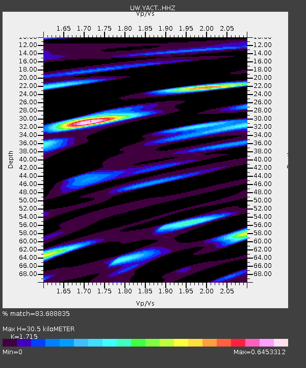
| Estimated Moho Depth: |
30.5 km |
| Estimated Crust Vp/Vs: |
1.72 |
| Assumed Crust Vp: |
6.566 km/s |
| Estimated Crust Vs: |
3.829 km/s |
| Estimated Crust Poisson's Ratio: |
0.24 |
|
| Radial Match: |
83.688835 % |
| Radial Bump: |
400 |
| Transverse Match: |
77.40933 % |
| Transverse Bump: |
400 |
| SOD ConfigId: |
7422571 |
| Insert Time: |
2019-04-22 16:30:07.281 +0000 |
| GWidth: |
2.5 |
| Max Bumps: |
400 |
| Tol: |
0.001 |
|

Signal To Noise
| Channel | StoN | STA | LTA |
| UW:YACT: :HHZ:20160528T05:50:07.367981Z | 113.27374 | 1.1757759E-5 | 1.03799515E-7 |
| UW:YACT: :HHN:20160528T05:50:07.367981Z | 24.779331 | 2.6644407E-6 | 1.0752674E-7 |
| UW:YACT: :HHE:20160528T05:50:07.367981Z | 17.67578 | 1.73172E-6 | 9.797136E-8 |
| Arrivals |
| Ps | 3.4 SECOND |
| PpPs | 12 SECOND |
| PsPs/PpSs | 16 SECOND |


