You are here: Home > Network List > XD14 - Illuminating the architecture of the greater Mount St. Helens magmatic systems f Stations List
> Station ME04 "Mount St Helens, WA" > Earthquake Result Viewer
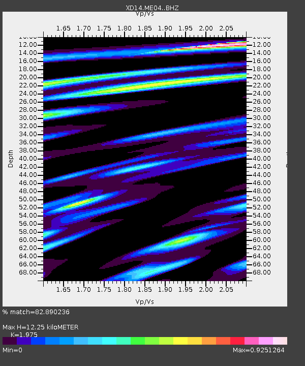
ME04 "Mount St Helens, WA" - Earthquake Result Viewer
| Earthquake location: |
South Of Fiji Islands |
| Earthquake latitude/longitude: |
-22.0/-178.2 |
| Earthquake time(UTC): |
2016/05/28 (149) 05:38:51 GMT |
| Earthquake Depth: |
417 km |
| Earthquake Magnitude: |
6.6 MO |
| Earthquake Catalog/Contributor: |
NEIC PDE/NEIC ALERT |
|
| Network: |
XD Illuminating the architecture of the greater Mount St. Helens magmatic systems f |
| Station: |
ME04 "Mount St Helens, WA" |
| Lat/Lon: |
46.45 N/122.35 W |
| Elevation: |
730 m |
|
| Distance: |
84.8 deg |
| Az: |
35.051 deg |
| Baz: |
230.421 deg |
| Ray Param: |
0.044132955 |
| Estimated Moho Depth: |
12.25 km |
| Estimated Crust Vp/Vs: |
1.98 |
| Assumed Crust Vp: |
6.566 km/s |
| Estimated Crust Vs: |
3.325 km/s |
| Estimated Crust Poisson's Ratio: |
0.33 |
|
| Radial Match: |
82.890236 % |
| Radial Bump: |
400 |
| Transverse Match: |
69.507866 % |
| Transverse Bump: |
400 |
| SOD ConfigId: |
7422571 |
| Insert Time: |
2019-04-22 16:30:20.393 +0000 |
| GWidth: |
2.5 |
| Max Bumps: |
400 |
| Tol: |
0.001 |
|

Signal To Noise
| Channel | StoN | STA | LTA |
| XD:ME04: :BHZ:20160528T05:50:09.179993Z | 135.84137 | 1.2820495E-5 | 9.437842E-8 |
| XD:ME04: :BHN:20160528T05:50:09.179993Z | 15.603792 | 1.4297655E-6 | 9.162936E-8 |
| XD:ME04: :BHE:20160528T05:50:09.179993Z | 43.34971 | 3.3078218E-6 | 7.630552E-8 |
| Arrivals |
| Ps | 1.9 SECOND |
| PpPs | 5.4 SECOND |
| PsPs/PpSs | 7.3 SECOND |


