You are here: Home > Network List > XD14 - Illuminating the architecture of the greater Mount St. Helens magmatic systems f Stations List
> Station MG10 "Mount St Helens, WA" > Earthquake Result Viewer
MG10 "Mount St Helens, WA" - Earthquake Result Viewer
| Earthquake location: |
South Of Fiji Islands |
| Earthquake latitude/longitude: |
-22.0/-178.2 |
| Earthquake time(UTC): |
2016/05/28 (149) 05:38:51 GMT |
| Earthquake Depth: |
417 km |
| Earthquake Magnitude: |
6.6 MO |
| Earthquake Catalog/Contributor: |
NEIC PDE/NEIC ALERT |
|
| Network: |
XD Illuminating the architecture of the greater Mount St. Helens magmatic systems f |
| Station: |
MG10 "Mount St Helens, WA" |
| Lat/Lon: |
46.34 N/121.66 W |
| Elevation: |
893 m |
|
| Distance: |
85.1 deg |
| Az: |
35.438 deg |
| Baz: |
230.957 deg |
| Ray Param: |
0.043920122 |
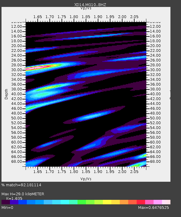
| Estimated Moho Depth: |
29.0 km |
| Estimated Crust Vp/Vs: |
1.63 |
| Assumed Crust Vp: |
6.597 km/s |
| Estimated Crust Vs: |
4.035 km/s |
| Estimated Crust Poisson's Ratio: |
0.20 |
|
| Radial Match: |
92.181114 % |
| Radial Bump: |
344 |
| Transverse Match: |
80.47214 % |
| Transverse Bump: |
400 |
| SOD ConfigId: |
7422571 |
| Insert Time: |
2019-04-22 16:30:30.849 +0000 |
| GWidth: |
2.5 |
| Max Bumps: |
400 |
| Tol: |
0.001 |
|

Signal To Noise
| Channel | StoN | STA | LTA |
| XD:MG10: :BHZ:20160528T05:50:10.659973Z | 114.31971 | 1.0547075E-5 | 9.225947E-8 |
| XD:MG10: :BHN:20160528T05:50:10.659973Z | 38.364098 | 2.6480664E-6 | 6.9024594E-8 |
| XD:MG10: :BHE:20160528T05:50:10.659973Z | 53.549633 | 3.8645717E-6 | 7.216803E-8 |
| Arrivals |
| Ps | 2.9 SECOND |
| PpPs | 11 SECOND |
| PsPs/PpSs | 14 SECOND |


