You are here: Home > Network List > XD14 - Illuminating the architecture of the greater Mount St. Helens magmatic systems f Stations List
> Station MJ07 "Mount St Helens, WA" > Earthquake Result Viewer
MJ07 "Mount St Helens, WA" - Earthquake Result Viewer
| Earthquake location: |
South Of Fiji Islands |
| Earthquake latitude/longitude: |
-22.0/-178.2 |
| Earthquake time(UTC): |
2016/05/28 (149) 05:38:51 GMT |
| Earthquake Depth: |
417 km |
| Earthquake Magnitude: |
6.6 MO |
| Earthquake Catalog/Contributor: |
NEIC PDE/NEIC ALERT |
|
| Network: |
XD Illuminating the architecture of the greater Mount St. Helens magmatic systems f |
| Station: |
MJ07 "Mount St Helens, WA" |
| Lat/Lon: |
46.18 N/122.06 W |
| Elevation: |
509 m |
|
| Distance: |
84.8 deg |
| Az: |
35.393 deg |
| Baz: |
230.666 deg |
| Ray Param: |
0.04414281 |
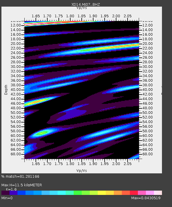
| Estimated Moho Depth: |
11.5 km |
| Estimated Crust Vp/Vs: |
1.60 |
| Assumed Crust Vp: |
6.566 km/s |
| Estimated Crust Vs: |
4.104 km/s |
| Estimated Crust Poisson's Ratio: |
0.18 |
|
| Radial Match: |
81.281166 % |
| Radial Bump: |
400 |
| Transverse Match: |
75.64064 % |
| Transverse Bump: |
400 |
| SOD ConfigId: |
7422571 |
| Insert Time: |
2019-04-22 16:30:43.931 +0000 |
| GWidth: |
2.5 |
| Max Bumps: |
400 |
| Tol: |
0.001 |
|

Signal To Noise
| Channel | StoN | STA | LTA |
| XD:MJ07: :BHZ:20160528T05:50:09.109985Z | 86.100975 | 7.4347954E-6 | 8.634972E-8 |
| XD:MJ07: :BHN:20160528T05:50:09.109985Z | 35.276897 | 2.0482319E-6 | 5.8061563E-8 |
| XD:MJ07: :BHE:20160528T05:50:09.109985Z | 20.097504 | 1.627032E-6 | 8.0956916E-8 |
| Arrivals |
| Ps | 1.1 SECOND |
| PpPs | 4.4 SECOND |
| PsPs/PpSs | 5.5 SECOND |


