You are here: Home > Network List > XD14 - Illuminating the architecture of the greater Mount St. Helens magmatic systems f Stations List
> Station ML07 "Mount St Helens, WA" > Earthquake Result Viewer
ML07 "Mount St Helens, WA" - Earthquake Result Viewer
| Earthquake location: |
South Of Fiji Islands |
| Earthquake latitude/longitude: |
-22.0/-178.2 |
| Earthquake time(UTC): |
2016/05/28 (149) 05:38:51 GMT |
| Earthquake Depth: |
417 km |
| Earthquake Magnitude: |
6.6 MO |
| Earthquake Catalog/Contributor: |
NEIC PDE/NEIC ALERT |
|
| Network: |
XD Illuminating the architecture of the greater Mount St. Helens magmatic systems f |
| Station: |
ML07 "Mount St Helens, WA" |
| Lat/Lon: |
46.07 N/122.12 W |
| Elevation: |
694 m |
|
| Distance: |
84.7 deg |
| Az: |
35.447 deg |
| Baz: |
230.628 deg |
| Ray Param: |
0.044210523 |
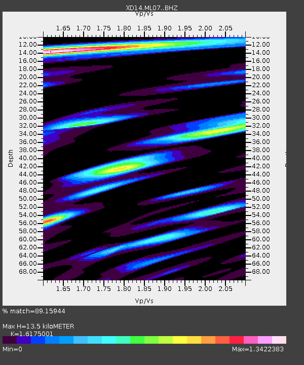
| Estimated Moho Depth: |
13.5 km |
| Estimated Crust Vp/Vs: |
1.62 |
| Assumed Crust Vp: |
6.566 km/s |
| Estimated Crust Vs: |
4.059 km/s |
| Estimated Crust Poisson's Ratio: |
0.19 |
|
| Radial Match: |
89.15944 % |
| Radial Bump: |
400 |
| Transverse Match: |
91.42921 % |
| Transverse Bump: |
365 |
| SOD ConfigId: |
7422571 |
| Insert Time: |
2019-04-22 16:30:51.265 +0000 |
| GWidth: |
2.5 |
| Max Bumps: |
400 |
| Tol: |
0.001 |
|

Signal To Noise
| Channel | StoN | STA | LTA |
| XD:ML07: :BHZ:20160528T05:50:08.61499Z | 114.788185 | 1.3155739E-5 | 1.14608824E-7 |
| XD:ML07: :BHN:20160528T05:50:08.61499Z | 30.55643 | 2.8884133E-6 | 9.452718E-8 |
| XD:ML07: :BHE:20160528T05:50:08.61499Z | 20.279398 | 2.0015984E-6 | 9.870107E-8 |
| Arrivals |
| Ps | 1.3 SECOND |
| PpPs | 5.2 SECOND |
| PsPs/PpSs | 6.5 SECOND |


