You are here: Home > Network List > YN10 - San Jacinto Fault Zone Stations List
> Station JFN4 JFN4 > Earthquake Result Viewer
JFN4 JFN4 - Earthquake Result Viewer
| Earthquake location: |
South Of Fiji Islands |
| Earthquake latitude/longitude: |
-22.0/-178.2 |
| Earthquake time(UTC): |
2016/05/28 (149) 05:38:51 GMT |
| Earthquake Depth: |
417 km |
| Earthquake Magnitude: |
6.6 MO |
| Earthquake Catalog/Contributor: |
NEIC PDE/NEIC ALERT |
|
| Network: |
YN San Jacinto Fault Zone |
| Station: |
JFN4 JFN4 |
| Lat/Lon: |
33.42 N/116.40 W |
| Elevation: |
646 m |
|
| Distance: |
80.6 deg |
| Az: |
48.307 deg |
| Baz: |
235.947 deg |
| Ray Param: |
0.046977933 |
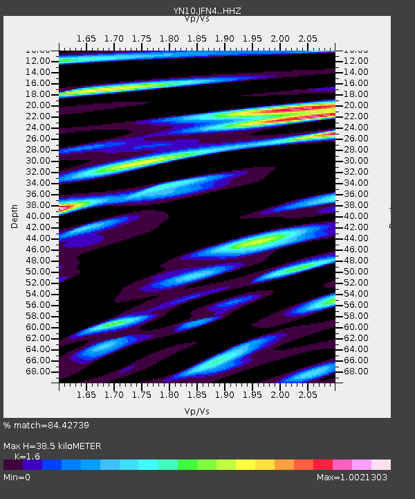
| Estimated Moho Depth: |
38.5 km |
| Estimated Crust Vp/Vs: |
1.60 |
| Assumed Crust Vp: |
6.264 km/s |
| Estimated Crust Vs: |
3.915 km/s |
| Estimated Crust Poisson's Ratio: |
0.18 |
|
| Radial Match: |
84.42739 % |
| Radial Bump: |
400 |
| Transverse Match: |
73.73731 % |
| Transverse Bump: |
400 |
| SOD ConfigId: |
7422571 |
| Insert Time: |
2019-04-22 16:31:37.741 +0000 |
| GWidth: |
2.5 |
| Max Bumps: |
400 |
| Tol: |
0.001 |
|

Signal To Noise
| Channel | StoN | STA | LTA |
| YN:JFN4: :HHZ:20160528T05:49:48.309021Z | 56.03398 | 6.98728E-6 | 1.246972E-7 |
| YN:JFN4: :HHN:20160528T05:49:48.309021Z | 13.478473 | 1.2088444E-6 | 8.968705E-8 |
| YN:JFN4: :HHE:20160528T05:49:48.309021Z | 17.279545 | 1.7917407E-6 | 1.03691434E-7 |
| Arrivals |
| Ps | 3.8 SECOND |
| PpPs | 16 SECOND |
| PsPs/PpSs | 19 SECOND |


