You are here: Home > Network List > YN10 - San Jacinto Fault Zone Stations List
> Station JFS2 JFS2 > Earthquake Result Viewer
JFS2 JFS2 - Earthquake Result Viewer
| Earthquake location: |
South Of Fiji Islands |
| Earthquake latitude/longitude: |
-22.0/-178.2 |
| Earthquake time(UTC): |
2016/05/28 (149) 05:38:51 GMT |
| Earthquake Depth: |
417 km |
| Earthquake Magnitude: |
6.6 MO |
| Earthquake Catalog/Contributor: |
NEIC PDE/NEIC ALERT |
|
| Network: |
YN San Jacinto Fault Zone |
| Station: |
JFS2 JFS2 |
| Lat/Lon: |
33.42 N/116.40 W |
| Elevation: |
645 m |
|
| Distance: |
80.6 deg |
| Az: |
48.308 deg |
| Baz: |
235.946 deg |
| Ray Param: |
0.046979293 |
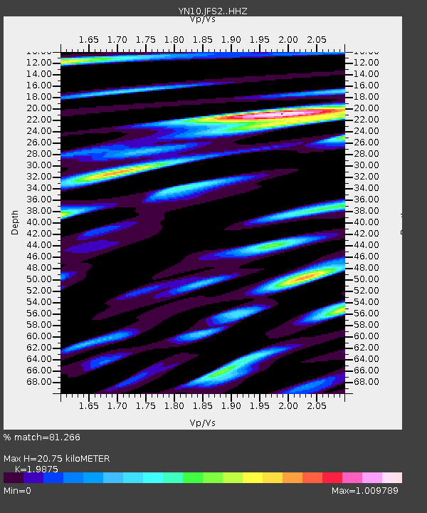
| Estimated Moho Depth: |
20.75 km |
| Estimated Crust Vp/Vs: |
1.99 |
| Assumed Crust Vp: |
6.264 km/s |
| Estimated Crust Vs: |
3.152 km/s |
| Estimated Crust Poisson's Ratio: |
0.33 |
|
| Radial Match: |
81.266 % |
| Radial Bump: |
400 |
| Transverse Match: |
75.70146 % |
| Transverse Bump: |
400 |
| SOD ConfigId: |
7422571 |
| Insert Time: |
2019-04-22 16:31:39.255 +0000 |
| GWidth: |
2.5 |
| Max Bumps: |
400 |
| Tol: |
0.001 |
|

Signal To Noise
| Channel | StoN | STA | LTA |
| YN:JFS2: :HHZ:20160528T05:49:48.299011Z | 54.492058 | 6.718774E-6 | 1.2329822E-7 |
| YN:JFS2: :HHN:20160528T05:49:48.299011Z | 9.403267 | 9.94688E-7 | 1.05781105E-7 |
| YN:JFS2: :HHE:20160528T05:49:48.299011Z | 16.68878 | 1.7755315E-6 | 1.0639073E-7 |
| Arrivals |
| Ps | 3.3 SECOND |
| PpPs | 9.7 SECOND |
| PsPs/PpSs | 13 SECOND |


