You are here: Home > Network List > YT07 - POLENET Stations List
> Station MA10 Polenet mini-array MA10 > Earthquake Result Viewer
MA10 Polenet mini-array MA10 - Earthquake Result Viewer
| Earthquake location: |
South Of Fiji Islands |
| Earthquake latitude/longitude: |
-22.0/-178.2 |
| Earthquake time(UTC): |
2016/05/28 (149) 05:38:51 GMT |
| Earthquake Depth: |
417 km |
| Earthquake Magnitude: |
6.6 MO |
| Earthquake Catalog/Contributor: |
NEIC PDE/NEIC ALERT |
|
| Network: |
YT POLENET |
| Station: |
MA10 Polenet mini-array MA10 |
| Lat/Lon: |
78.60 S/109.00 W |
| Elevation: |
1658 m |
|
| Distance: |
64.5 deg |
| Az: |
168.109 deg |
| Baz: |
286.042 deg |
| Ray Param: |
0.057487506 |
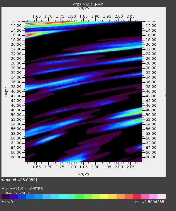
| Estimated Moho Depth: |
11.0 km |
| Estimated Crust Vp/Vs: |
1.62 |
| Assumed Crust Vp: |
5.872 km/s |
| Estimated Crust Vs: |
3.619 km/s |
| Estimated Crust Poisson's Ratio: |
0.19 |
|
| Radial Match: |
95.89591 % |
| Radial Bump: |
314 |
| Transverse Match: |
84.55545 % |
| Transverse Bump: |
342 |
| SOD ConfigId: |
7422571 |
| Insert Time: |
2019-04-22 16:32:00.860 +0000 |
| GWidth: |
2.5 |
| Max Bumps: |
400 |
| Tol: |
0.001 |
|

Signal To Noise
| Channel | StoN | STA | LTA |
| YT:MA10: :HHZ:20160528T05:48:14.939026Z | 9.033756 | 1.9588065E-6 | 2.168319E-7 |
| YT:MA10: :HHN:20160528T05:48:14.939026Z | 0.65259683 | 1.4297325E-7 | 2.1908357E-7 |
| YT:MA10: :HHE:20160528T05:48:14.939026Z | 3.7646677 | 4.4241696E-7 | 1.175182E-7 |
| Arrivals |
| Ps | 1.2 SECOND |
| PpPs | 4.7 SECOND |
| PsPs/PpSs | 5.9 SECOND |


