You are here: Home > Network List > YT07 - POLENET Stations List
> Station SILY SILY > Earthquake Result Viewer
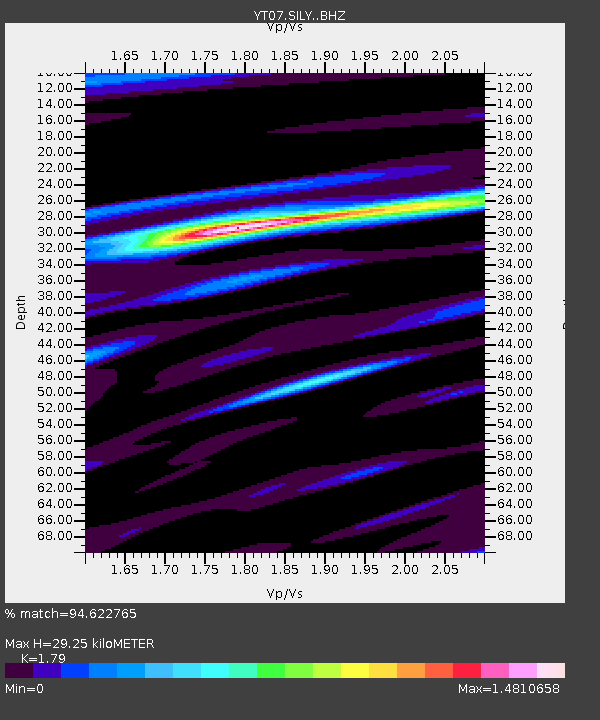
SILY SILY - Earthquake Result Viewer
| Earthquake location: |
South Of Fiji Islands |
| Earthquake latitude/longitude: |
-22.0/-178.2 |
| Earthquake time(UTC): |
2016/05/28 (149) 05:38:51 GMT |
| Earthquake Depth: |
417 km |
| Earthquake Magnitude: |
6.6 MO |
| Earthquake Catalog/Contributor: |
NEIC PDE/NEIC ALERT |
|
| Network: |
YT POLENET |
| Station: |
SILY SILY |
| Lat/Lon: |
77.13 S/125.97 W |
| Elevation: |
2093 m |
|
| Distance: |
60.6 deg |
| Az: |
168.274 deg |
| Baz: |
302.706 deg |
| Ray Param: |
0.05992665 |
| Estimated Moho Depth: |
29.25 km |
| Estimated Crust Vp/Vs: |
1.79 |
| Assumed Crust Vp: |
6.138 km/s |
| Estimated Crust Vs: |
3.429 km/s |
| Estimated Crust Poisson's Ratio: |
0.27 |
|
| Radial Match: |
94.622765 % |
| Radial Bump: |
389 |
| Transverse Match: |
79.04746 % |
| Transverse Bump: |
400 |
| SOD ConfigId: |
7422571 |
| Insert Time: |
2019-04-22 16:32:06.213 +0000 |
| GWidth: |
2.5 |
| Max Bumps: |
400 |
| Tol: |
0.001 |
|

Signal To Noise
| Channel | StoN | STA | LTA |
| YT:SILY: :BHZ:20160528T05:47:49.825012Z | 7.0381308 | 1.1776262E-6 | 1.6732088E-7 |
| YT:SILY: :BHN:20160528T05:47:49.825012Z | 1.9807779 | 6.592823E-7 | 3.328401E-7 |
| YT:SILY: :BHE:20160528T05:47:49.825012Z | 1.3372568 | 3.9462768E-7 | 2.9510238E-7 |
| Arrivals |
| Ps | 3.9 SECOND |
| PpPs | 13 SECOND |
| PsPs/PpSs | 17 SECOND |


