You are here: Home > Network List > 8G - 2016 Pedernales Earthquake Aftershock Deployment Ecuador Stations List
> Station EC18 EC18 > Earthquake Result Viewer
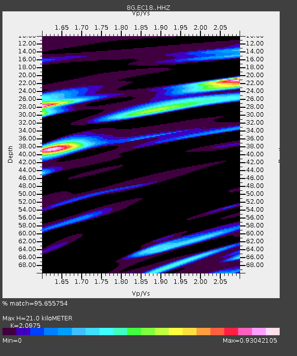
EC18 EC18 - Earthquake Result Viewer
| Earthquake location: |
South Sandwich Islands Region |
| Earthquake latitude/longitude: |
-56.2/-26.9 |
| Earthquake time(UTC): |
2016/05/28 (149) 09:46:59 GMT |
| Earthquake Depth: |
73 km |
| Earthquake Magnitude: |
7.2 MWW, 7.3 MI |
| Earthquake Catalog/Contributor: |
NEIC PDE/NEIC COMCAT |
|
| Network: |
8G 2016 Pedernales Earthquake Aftershock Deployment Ecuador |
| Station: |
EC18 EC18 |
| Lat/Lon: |
0.21 S/80.18 W |
| Elevation: |
243 m |
|
| Distance: |
70.3 deg |
| Az: |
301.628 deg |
| Baz: |
151.587 deg |
| Ray Param: |
0.054909825 |
| Estimated Moho Depth: |
21.0 km |
| Estimated Crust Vp/Vs: |
2.10 |
| Assumed Crust Vp: |
6.183 km/s |
| Estimated Crust Vs: |
2.948 km/s |
| Estimated Crust Poisson's Ratio: |
0.35 |
|
| Radial Match: |
95.655754 % |
| Radial Bump: |
400 |
| Transverse Match: |
91.80863 % |
| Transverse Bump: |
400 |
| SOD ConfigId: |
7422571 |
| Insert Time: |
2019-04-22 16:33:21.263 +0000 |
| GWidth: |
2.5 |
| Max Bumps: |
400 |
| Tol: |
0.001 |
|

Signal To Noise
| Channel | StoN | STA | LTA |
| 8G:EC18: :HHZ:20160528T09:57:33.999973Z | 43.23194 | 6.376434E-6 | 1.474936E-7 |
| 8G:EC18: :HHN:20160528T09:57:33.999973Z | 5.672823 | 2.3226703E-6 | 4.0943817E-7 |
| 8G:EC18: :HHE:20160528T09:57:33.999973Z | 4.718122 | 1.9351285E-6 | 4.1014806E-7 |
| Arrivals |
| Ps | 3.8 SECOND |
| PpPs | 10 SECOND |
| PsPs/PpSs | 14 SECOND |


