You are here: Home > Network List > C1 - Red Sismologica Nacional Stations List
> Station CO01 Juntas del Toro > Earthquake Result Viewer
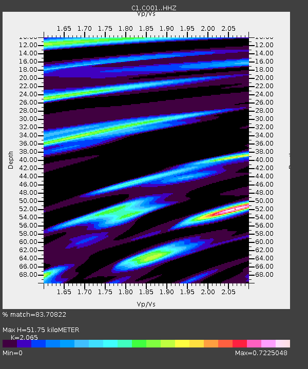
CO01 Juntas del Toro - Earthquake Result Viewer
| Earthquake location: |
South Sandwich Islands Region |
| Earthquake latitude/longitude: |
-56.2/-26.9 |
| Earthquake time(UTC): |
2016/05/28 (149) 09:46:59 GMT |
| Earthquake Depth: |
73 km |
| Earthquake Magnitude: |
7.2 MWW, 7.3 MI |
| Earthquake Catalog/Contributor: |
NEIC PDE/NEIC COMCAT |
|
| Network: |
C1 Red Sismologica Nacional |
| Station: |
CO01 Juntas del Toro |
| Lat/Lon: |
29.98 S/70.09 W |
| Elevation: |
2157 m |
|
| Distance: |
40.0 deg |
| Az: |
292.555 deg |
| Baz: |
143.502 deg |
| Ray Param: |
0.07442 |
| Estimated Moho Depth: |
51.75 km |
| Estimated Crust Vp/Vs: |
2.07 |
| Assumed Crust Vp: |
6.481 km/s |
| Estimated Crust Vs: |
3.138 km/s |
| Estimated Crust Poisson's Ratio: |
0.35 |
|
| Radial Match: |
83.70822 % |
| Radial Bump: |
391 |
| Transverse Match: |
64.193634 % |
| Transverse Bump: |
400 |
| SOD ConfigId: |
7422571 |
| Insert Time: |
2019-04-22 16:33:57.110 +0000 |
| GWidth: |
2.5 |
| Max Bumps: |
400 |
| Tol: |
0.001 |
|

Signal To Noise
| Channel | StoN | STA | LTA |
| C1:CO01: :HHZ:20160528T09:53:56.679996Z | 24.235365 | 3.7932846E-6 | 1.5651857E-7 |
| C1:CO01: :HHN:20160528T09:53:56.679996Z | 6.960197 | 1.2992058E-6 | 1.866622E-7 |
| C1:CO01: :HHE:20160528T09:53:56.679996Z | 7.2519073 | 8.860637E-7 | 1.2218354E-7 |
| Arrivals |
| Ps | 9.0 SECOND |
| PpPs | 23 SECOND |
| PsPs/PpSs | 32 SECOND |


