You are here: Home > Network List > C1 - Red Sismologica Nacional Stations List
> Station LL02 Futaleufu > Earthquake Result Viewer
LL02 Futaleufu - Earthquake Result Viewer
| Earthquake location: |
South Sandwich Islands Region |
| Earthquake latitude/longitude: |
-56.2/-26.9 |
| Earthquake time(UTC): |
2016/05/28 (149) 09:46:59 GMT |
| Earthquake Depth: |
73 km |
| Earthquake Magnitude: |
7.2 MWW, 7.3 MI |
| Earthquake Catalog/Contributor: |
NEIC PDE/NEIC COMCAT |
|
| Network: |
C1 Red Sismologica Nacional |
| Station: |
LL02 Futaleufu |
| Lat/Lon: |
43.19 S/71.85 W |
| Elevation: |
368 m |
|
| Distance: |
31.3 deg |
| Az: |
275.317 deg |
| Baz: |
130.466 deg |
| Ray Param: |
0.07897496 |
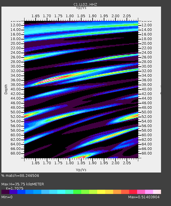
| Estimated Moho Depth: |
35.75 km |
| Estimated Crust Vp/Vs: |
1.71 |
| Assumed Crust Vp: |
6.597 km/s |
| Estimated Crust Vs: |
3.864 km/s |
| Estimated Crust Poisson's Ratio: |
0.24 |
|
| Radial Match: |
88.246506 % |
| Radial Bump: |
291 |
| Transverse Match: |
70.741905 % |
| Transverse Bump: |
400 |
| SOD ConfigId: |
7422571 |
| Insert Time: |
2019-04-22 16:34:00.549 +0000 |
| GWidth: |
2.5 |
| Max Bumps: |
400 |
| Tol: |
0.001 |
|

Signal To Noise
| Channel | StoN | STA | LTA |
| C1:LL02: :HHZ:20160528T09:52:41.790012Z | 13.570611 | 2.6127416E-6 | 1.925294E-7 |
| C1:LL02: :HHN:20160528T09:52:41.790012Z | 6.496207 | 9.748802E-7 | 1.5006914E-7 |
| C1:LL02: :HHE:20160528T09:52:41.790012Z | 10.029493 | 1.1117467E-6 | 1.1084774E-7 |
| Arrivals |
| Ps | 4.2 SECOND |
| PpPs | 13 SECOND |
| PsPs/PpSs | 18 SECOND |


